You are here: Home > Network List > TA - USArray Transportable Network (new EarthScope stations) Stations List
> Station M50A Fremont, OH, USA > Earthquake Result Viewer
M50A Fremont, OH, USA - Earthquake Result Viewer
| Earthquake location: |
Near Coast Of Northern Peru |
| Earthquake latitude/longitude: |
-5.6/-81.0 |
| Earthquake time(UTC): |
2014/03/15 (074) 23:51:33 GMT |
| Earthquake Depth: |
29 km |
| Earthquake Magnitude: |
6.3 MWW, 6.2 MWB, 6.3 MWC |
| Earthquake Catalog/Contributor: |
NEIC PDE/NEIC COMCAT |
|
| Network: |
TA USArray Transportable Network (new EarthScope stations) |
| Station: |
M50A Fremont, OH, USA |
| Lat/Lon: |
41.40 N/83.04 W |
| Elevation: |
176 m |
|
| Distance: |
46.8 deg |
| Az: |
357.847 deg |
| Baz: |
177.151 deg |
| Ray Param: |
0.070363626 |
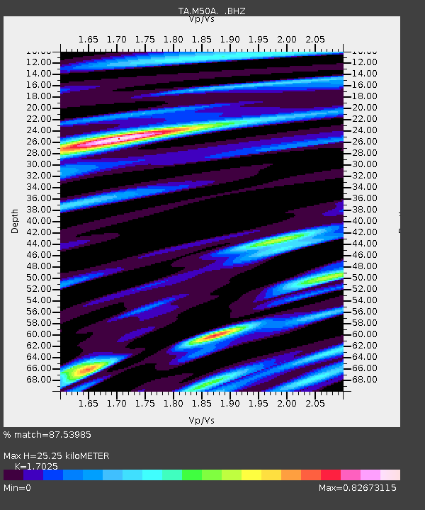
| Estimated Moho Depth: |
25.25 km |
| Estimated Crust Vp/Vs: |
1.70 |
| Assumed Crust Vp: |
6.498 km/s |
| Estimated Crust Vs: |
3.816 km/s |
| Estimated Crust Poisson's Ratio: |
0.24 |
|
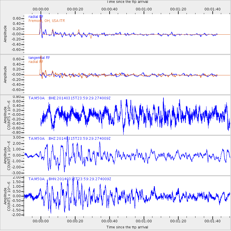
| Radial Match: |
87.53985 % |
| Radial Bump: |
400 |
| Transverse Match: |
65.59569 % |
| Transverse Bump: |
400 |
| SOD ConfigId: |
626651 |
| Insert Time: |
2014-04-21 06:49:28.872 +0000 |
| GWidth: |
2.5 |
| Max Bumps: |
400 |
| Tol: |
0.001 |
|
Signal To Noise
| Channel | StoN | STA | LTA |
| TA:M50A: :BHZ:20140315T23:59:29.274009Z | 5.0441976 | 1.1147946E-6 | 2.2100534E-7 |
| TA:M50A: :BHN:20140315T23:59:29.274009Z | 3.7111518 | 7.1434914E-7 | 1.9248719E-7 |
| TA:M50A: :BHE:20140315T23:59:29.274009Z | 0.6144824 | 1.3875122E-7 | 2.2580177E-7 |
| Arrivals |
| Ps | 2.9 SECOND |
| PpPs | 9.8 SECOND |
| PsPs/PpSs | 13 SECOND |


