You are here: Home > Network List > TA - USArray Transportable Network (new EarthScope stations) Stations List
> Station O48A Farmland, IN, USA > Earthquake Result Viewer
O48A Farmland, IN, USA - Earthquake Result Viewer
| Earthquake location: |
Near Coast Of Northern Peru |
| Earthquake latitude/longitude: |
-5.6/-81.0 |
| Earthquake time(UTC): |
2014/03/15 (074) 23:51:33 GMT |
| Earthquake Depth: |
29 km |
| Earthquake Magnitude: |
6.3 MWW, 6.2 MWB, 6.3 MWC |
| Earthquake Catalog/Contributor: |
NEIC PDE/NEIC COMCAT |
|
| Network: |
TA USArray Transportable Network (new EarthScope stations) |
| Station: |
O48A Farmland, IN, USA |
| Lat/Lon: |
40.26 N/85.16 W |
| Elevation: |
300 m |
|
| Distance: |
45.8 deg |
| Az: |
355.515 deg |
| Baz: |
174.163 deg |
| Ray Param: |
0.071004145 |
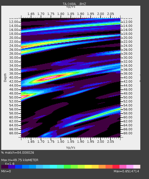
| Estimated Moho Depth: |
49.75 km |
| Estimated Crust Vp/Vs: |
1.60 |
| Assumed Crust Vp: |
6.498 km/s |
| Estimated Crust Vs: |
4.061 km/s |
| Estimated Crust Poisson's Ratio: |
0.18 |
|
| Radial Match: |
84.008026 % |
| Radial Bump: |
400 |
| Transverse Match: |
70.06277 % |
| Transverse Bump: |
400 |
| SOD ConfigId: |
626651 |
| Insert Time: |
2014-04-21 06:51:24.990 +0000 |
| GWidth: |
2.5 |
| Max Bumps: |
400 |
| Tol: |
0.001 |
|

Signal To Noise
| Channel | StoN | STA | LTA |
| TA:O48A: :BHZ:20140315T23:59:21.274985Z | 4.4605823 | 9.4815204E-7 | 2.125624E-7 |
| TA:O48A: :BHN:20140315T23:59:21.274985Z | 3.9279437 | 5.9587103E-7 | 1.517005E-7 |
| TA:O48A: :BHE:20140315T23:59:21.274985Z | 1.2159905 | 1.9980192E-7 | 1.6431207E-7 |
| Arrivals |
| Ps | 4.9 SECOND |
| PpPs | 19 SECOND |
| PsPs/PpSs | 23 SECOND |


