You are here: Home > Network List > TA - USArray Transportable Network (new EarthScope stations) Stations List
> Station R53A Hurricane, WV, USA > Earthquake Result Viewer
R53A Hurricane, WV, USA - Earthquake Result Viewer

| Earthquake location: |
Near Coast Of Northern Peru |
| Earthquake latitude/longitude: |
-5.6/-81.0 |
| Earthquake time(UTC): |
2014/03/15 (074) 23:51:33 GMT |
| Earthquake Depth: |
29 km |
| Earthquake Magnitude: |
6.3 MWW, 6.2 MWB, 6.3 MWC |
| Earthquake Catalog/Contributor: |
NEIC PDE/NEIC COMCAT |
|
| Network: |
TA USArray Transportable Network (new EarthScope stations) |
| Station: |
R53A Hurricane, WV, USA |
| Lat/Lon: |
38.33 N/81.95 W |
| Elevation: |
294 m |
|
| Distance: |
43.7 deg |
| Az: |
358.867 deg |
| Baz: |
178.567 deg |
| Ray Param: |
0.07232903 |
| Estimated Moho Depth: |
10.0 km |
| Estimated Crust Vp/Vs: |
1.60 |
| Assumed Crust Vp: |
6.207 km/s |
| Estimated Crust Vs: |
3.879 km/s |
| Estimated Crust Poisson's Ratio: |
0.18 |
|
| Radial Match: |
83.44611 % |
| Radial Bump: |
400 |
| Transverse Match: |
63.73018 % |
| Transverse Bump: |
400 |
| SOD ConfigId: |
626651 |
| Insert Time: |
2014-04-21 06:54:03.260 +0000 |
| GWidth: |
2.5 |
| Max Bumps: |
400 |
| Tol: |
0.001 |
|
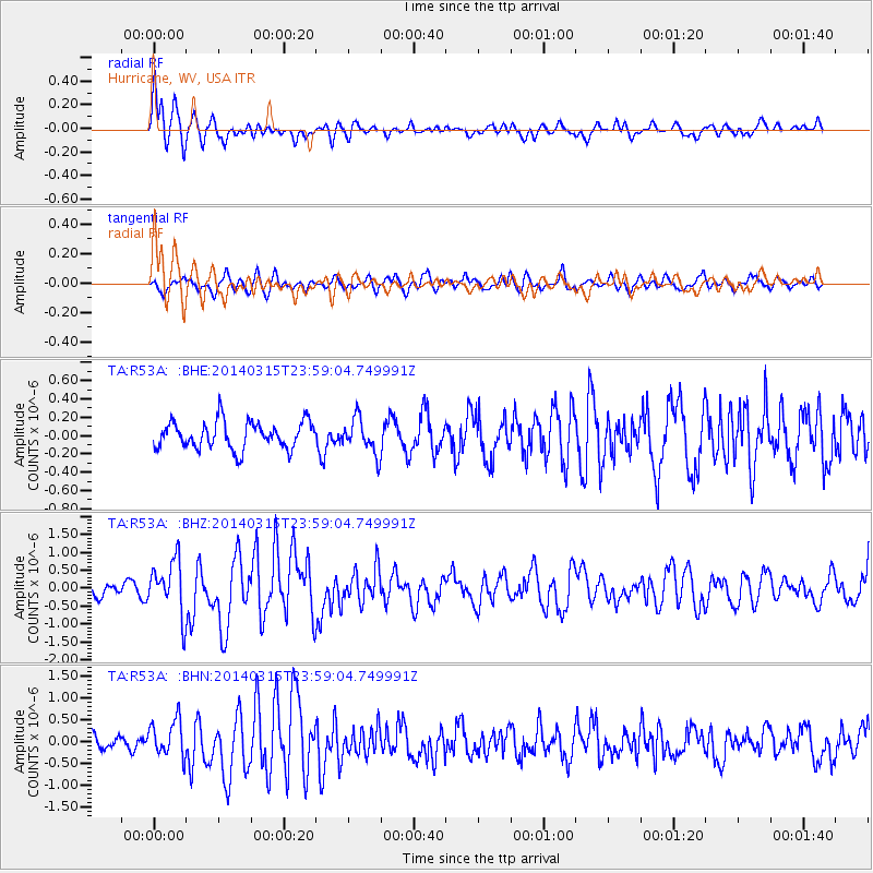
Signal To Noise
| Channel | StoN | STA | LTA |
| TA:R53A: :BHZ:20140315T23:59:04.749991Z | 3.5250697 | 7.583005E-7 | 2.1511646E-7 |
| TA:R53A: :BHN:20140315T23:59:04.749991Z | 2.7150977 | 4.2328372E-7 | 1.559E-7 |
| TA:R53A: :BHE:20140315T23:59:04.749991Z | 1.2746218 | 1.8893408E-7 | 1.4822756E-7 |
| Arrivals |
| Ps | 1.0 SECOND |
| PpPs | 3.9 SECOND |
| PsPs/PpSs | 4.9 SECOND |


