You are here: Home > Network List > TA - USArray Transportable Network (new EarthScope stations) Stations List
> Station TUL1 Leonard, OK, USA > Earthquake Result Viewer
TUL1 Leonard, OK, USA - Earthquake Result Viewer

| Earthquake location: |
Near Coast Of Northern Peru |
| Earthquake latitude/longitude: |
-5.6/-81.0 |
| Earthquake time(UTC): |
2014/03/15 (074) 23:51:33 GMT |
| Earthquake Depth: |
29 km |
| Earthquake Magnitude: |
6.3 MWW, 6.2 MWB, 6.3 MWC |
| Earthquake Catalog/Contributor: |
NEIC PDE/NEIC COMCAT |
|
| Network: |
TA USArray Transportable Network (new EarthScope stations) |
| Station: |
TUL1 Leonard, OK, USA |
| Lat/Lon: |
35.91 N/95.79 W |
| Elevation: |
256 m |
|
| Distance: |
43.6 deg |
| Az: |
342.444 deg |
| Baz: |
158.295 deg |
| Ray Param: |
0.072418936 |
| Estimated Moho Depth: |
63.5 km |
| Estimated Crust Vp/Vs: |
1.98 |
| Assumed Crust Vp: |
6.498 km/s |
| Estimated Crust Vs: |
3.286 km/s |
| Estimated Crust Poisson's Ratio: |
0.33 |
|
| Radial Match: |
92.2348 % |
| Radial Bump: |
400 |
| Transverse Match: |
78.80962 % |
| Transverse Bump: |
400 |
| SOD ConfigId: |
626651 |
| Insert Time: |
2014-04-21 06:56:32.331 +0000 |
| GWidth: |
2.5 |
| Max Bumps: |
400 |
| Tol: |
0.001 |
|
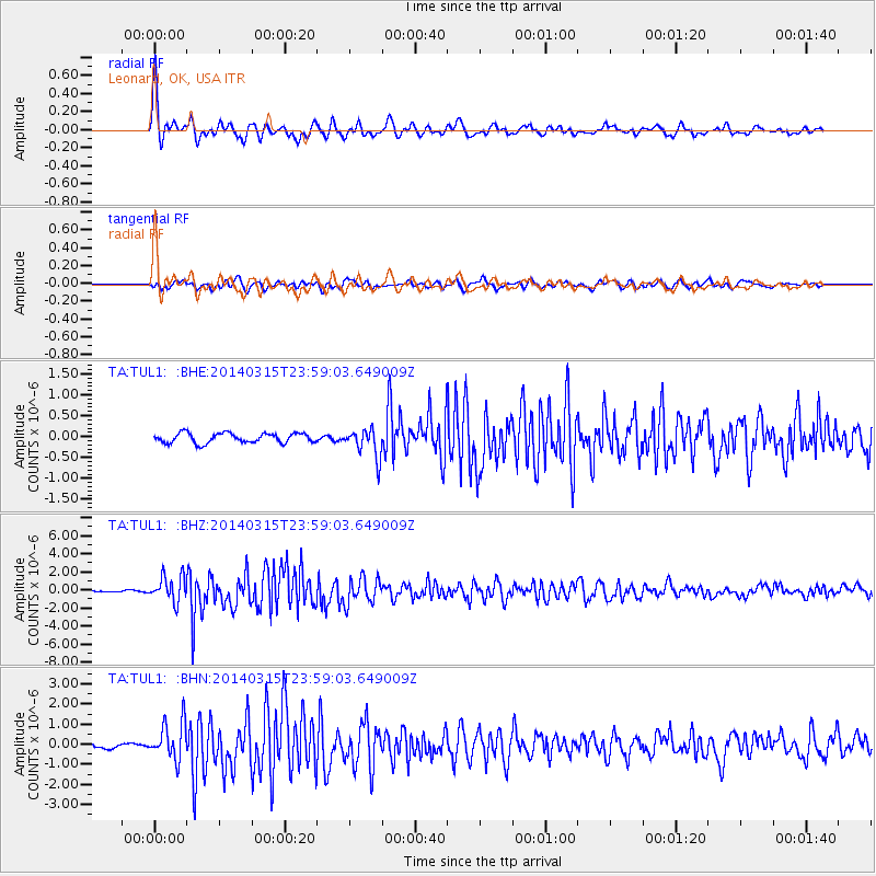
Signal To Noise
| Channel | StoN | STA | LTA |
| TA:TUL1: :BHZ:20140315T23:59:03.649009Z | 16.117025 | 1.4103588E-6 | 8.750739E-8 |
| TA:TUL1: :BHN:20140315T23:59:03.649009Z | 6.2856073 | 9.295282E-7 | 1.47882E-7 |
| TA:TUL1: :BHE:20140315T23:59:03.649009Z | 2.9401095 | 3.417781E-7 | 1.1624673E-7 |
| Arrivals |
| Ps | 10 SECOND |
| PpPs | 27 SECOND |
| PsPs/PpSs | 38 SECOND |


