You are here: Home > Network List > TA - USArray Transportable Network (new EarthScope stations) Stations List
> Station U59A Littleton, NC, USA > Earthquake Result Viewer
U59A Littleton, NC, USA - Earthquake Result Viewer
| Earthquake location: |
Near Coast Of Northern Peru |
| Earthquake latitude/longitude: |
-5.6/-81.0 |
| Earthquake time(UTC): |
2014/03/15 (074) 23:51:33 GMT |
| Earthquake Depth: |
29 km |
| Earthquake Magnitude: |
6.3 MWW, 6.2 MWB, 6.3 MWC |
| Earthquake Catalog/Contributor: |
NEIC PDE/NEIC COMCAT |
|
| Network: |
TA USArray Transportable Network (new EarthScope stations) |
| Station: |
U59A Littleton, NC, USA |
| Lat/Lon: |
36.35 N/77.79 W |
| Elevation: |
99 m |
|
| Distance: |
41.8 deg |
| Az: |
3.832 deg |
| Baz: |
184.726 deg |
| Ray Param: |
0.07349577 |
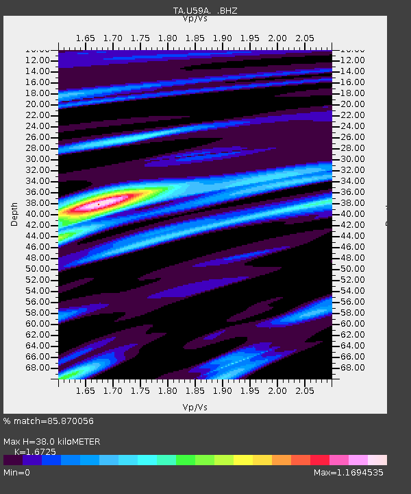
| Estimated Moho Depth: |
38.0 km |
| Estimated Crust Vp/Vs: |
1.67 |
| Assumed Crust Vp: |
6.565 km/s |
| Estimated Crust Vs: |
3.925 km/s |
| Estimated Crust Poisson's Ratio: |
0.22 |
|
| Radial Match: |
85.870056 % |
| Radial Bump: |
376 |
| Transverse Match: |
71.45397 % |
| Transverse Bump: |
400 |
| SOD ConfigId: |
626651 |
| Insert Time: |
2014-04-21 06:56:53.742 +0000 |
| GWidth: |
2.5 |
| Max Bumps: |
400 |
| Tol: |
0.001 |
|
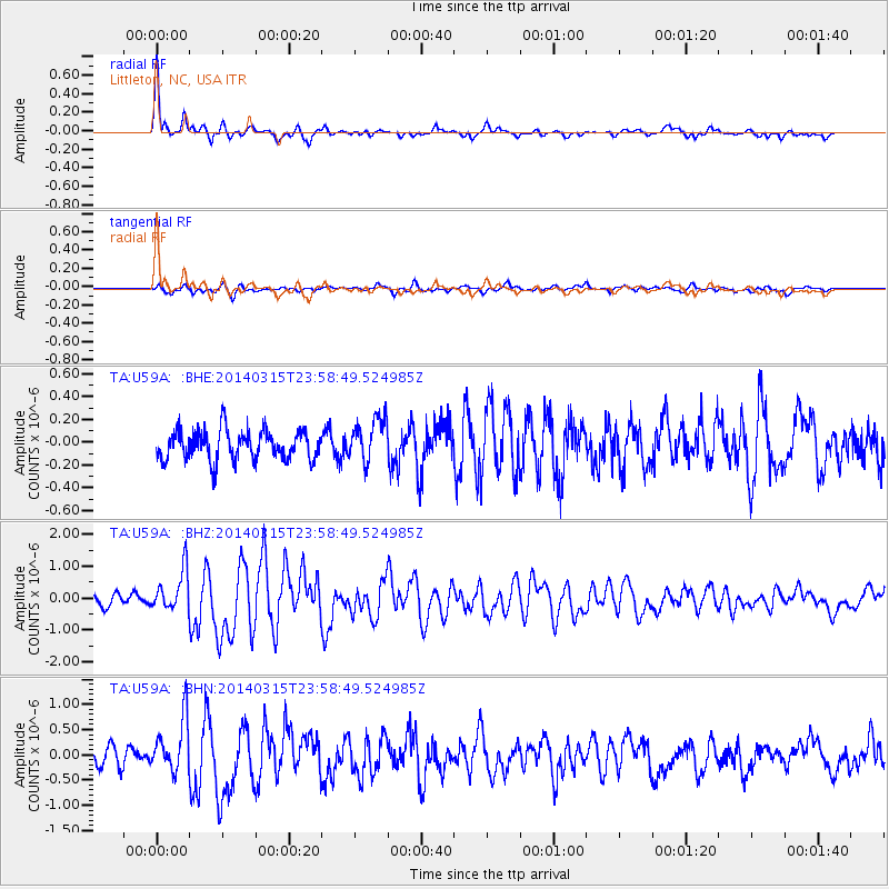
Signal To Noise
| Channel | StoN | STA | LTA |
| TA:U59A: :BHZ:20140315T23:58:49.524985Z | 3.8684826 | 6.381017E-7 | 1.6494884E-7 |
| TA:U59A: :BHN:20140315T23:58:49.524985Z | 3.445214 | 5.3588485E-7 | 1.5554473E-7 |
| TA:U59A: :BHE:20140315T23:58:49.524985Z | 1.4633323 | 1.9045078E-7 | 1.3014869E-7 |
| Arrivals |
| Ps | 4.2 SECOND |
| PpPs | 14 SECOND |
| PsPs/PpSs | 19 SECOND |


