You are here: Home > Network List > TA - USArray Transportable Network (new EarthScope stations) Stations List
> Station V58A Windy Hill, Pittsboro, NC, USA > Earthquake Result Viewer
V58A Windy Hill, Pittsboro, NC, USA - Earthquake Result Viewer

| Earthquake location: |
Near Coast Of Northern Peru |
| Earthquake latitude/longitude: |
-5.6/-81.0 |
| Earthquake time(UTC): |
2014/03/15 (074) 23:51:33 GMT |
| Earthquake Depth: |
29 km |
| Earthquake Magnitude: |
6.3 MWW, 6.2 MWB, 6.3 MWC |
| Earthquake Catalog/Contributor: |
NEIC PDE/NEIC COMCAT |
|
| Network: |
TA USArray Transportable Network (new EarthScope stations) |
| Station: |
V58A Windy Hill, Pittsboro, NC, USA |
| Lat/Lon: |
35.79 N/79.11 W |
| Elevation: |
127 m |
|
| Distance: |
41.2 deg |
| Az: |
2.273 deg |
| Baz: |
182.784 deg |
| Ray Param: |
0.07389246 |
| Estimated Moho Depth: |
42.0 km |
| Estimated Crust Vp/Vs: |
1.60 |
| Assumed Crust Vp: |
6.565 km/s |
| Estimated Crust Vs: |
4.103 km/s |
| Estimated Crust Poisson's Ratio: |
0.18 |
|
| Radial Match: |
89.28021 % |
| Radial Bump: |
356 |
| Transverse Match: |
67.400154 % |
| Transverse Bump: |
400 |
| SOD ConfigId: |
626651 |
| Insert Time: |
2014-04-21 06:57:10.715 +0000 |
| GWidth: |
2.5 |
| Max Bumps: |
400 |
| Tol: |
0.001 |
|
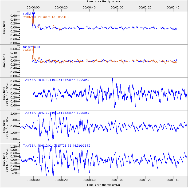
Signal To Noise
| Channel | StoN | STA | LTA |
| TA:V58A: :BHZ:20140315T23:58:44.399985Z | 4.153946 | 8.5699025E-7 | 2.0630752E-7 |
| TA:V58A: :BHN:20140315T23:58:44.399985Z | 4.197228 | 4.63805E-7 | 1.105027E-7 |
| TA:V58A: :BHE:20140315T23:58:44.399985Z | 0.7051012 | 9.597567E-8 | 1.3611617E-7 |
| Arrivals |
| Ps | 4.2 SECOND |
| PpPs | 15 SECOND |
| PsPs/PpSs | 20 SECOND |


