You are here: Home > Network List > TA - USArray Transportable Network (new EarthScope stations) Stations List
> Station W58A Raeford, NC, USA > Earthquake Result Viewer
W58A Raeford, NC, USA - Earthquake Result Viewer

| Earthquake location: |
Near Coast Of Northern Peru |
| Earthquake latitude/longitude: |
-5.6/-81.0 |
| Earthquake time(UTC): |
2014/03/15 (074) 23:51:33 GMT |
| Earthquake Depth: |
29 km |
| Earthquake Magnitude: |
6.3 MWW, 6.2 MWB, 6.3 MWC |
| Earthquake Catalog/Contributor: |
NEIC PDE/NEIC COMCAT |
|
| Network: |
TA USArray Transportable Network (new EarthScope stations) |
| Station: |
W58A Raeford, NC, USA |
| Lat/Lon: |
35.02 N/79.23 W |
| Elevation: |
84 m |
|
| Distance: |
40.4 deg |
| Az: |
2.182 deg |
| Baz: |
182.646 deg |
| Ray Param: |
0.074363664 |
| Estimated Moho Depth: |
37.0 km |
| Estimated Crust Vp/Vs: |
1.70 |
| Assumed Crust Vp: |
6.565 km/s |
| Estimated Crust Vs: |
3.861 km/s |
| Estimated Crust Poisson's Ratio: |
0.24 |
|
| Radial Match: |
87.235664 % |
| Radial Bump: |
369 |
| Transverse Match: |
68.75613 % |
| Transverse Bump: |
400 |
| SOD ConfigId: |
626651 |
| Insert Time: |
2014-04-21 06:57:39.353 +0000 |
| GWidth: |
2.5 |
| Max Bumps: |
400 |
| Tol: |
0.001 |
|
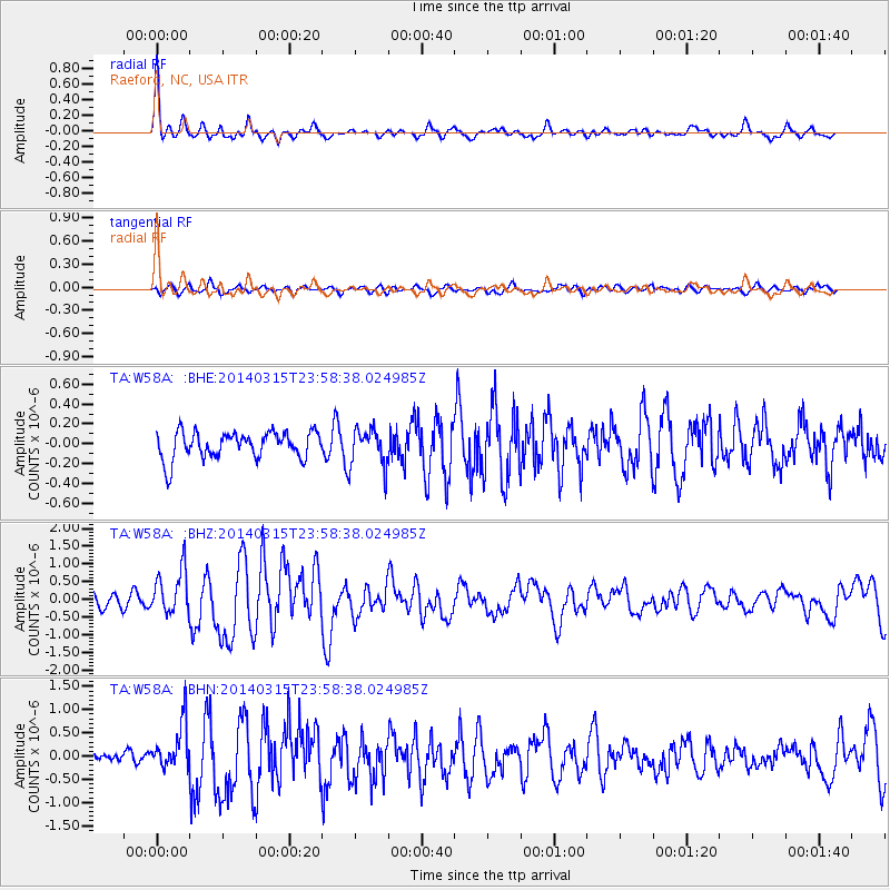
Signal To Noise
| Channel | StoN | STA | LTA |
| TA:W58A: :BHZ:20140315T23:58:38.024985Z | 2.7920792 | 6.24209E-7 | 2.2356423E-7 |
| TA:W58A: :BHN:20140315T23:58:38.024985Z | 5.013868 | 4.820363E-7 | 9.61406E-8 |
| TA:W58A: :BHE:20140315T23:58:38.024985Z | 1.4030771 | 1.9010456E-7 | 1.3549118E-7 |
| Arrivals |
| Ps | 4.3 SECOND |
| PpPs | 14 SECOND |
| PsPs/PpSs | 18 SECOND |


