You are here: Home > Network List > TA - USArray Transportable Network (new EarthScope stations) Stations List
> Station X40A Basin Creek Farm, Marlvern, AR, USA > Earthquake Result Viewer
X40A Basin Creek Farm, Marlvern, AR, USA - Earthquake Result Viewer
| Earthquake location: |
Near Coast Of Northern Peru |
| Earthquake latitude/longitude: |
-5.6/-81.0 |
| Earthquake time(UTC): |
2014/03/15 (074) 23:51:33 GMT |
| Earthquake Depth: |
29 km |
| Earthquake Magnitude: |
6.3 MWW, 6.2 MWB, 6.3 MWC |
| Earthquake Catalog/Contributor: |
NEIC PDE/NEIC COMCAT |
|
| Network: |
TA USArray Transportable Network (new EarthScope stations) |
| Station: |
X40A Basin Creek Farm, Marlvern, AR, USA |
| Lat/Lon: |
34.49 N/92.83 W |
| Elevation: |
158 m |
|
| Distance: |
41.4 deg |
| Az: |
345.103 deg |
| Baz: |
161.954 deg |
| Ray Param: |
0.073761106 |
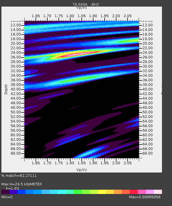
| Estimated Moho Depth: |
24.5 km |
| Estimated Crust Vp/Vs: |
1.83 |
| Assumed Crust Vp: |
6.498 km/s |
| Estimated Crust Vs: |
3.551 km/s |
| Estimated Crust Poisson's Ratio: |
0.29 |
|
| Radial Match: |
92.27111 % |
| Radial Bump: |
400 |
| Transverse Match: |
89.118546 % |
| Transverse Bump: |
400 |
| SOD ConfigId: |
626651 |
| Insert Time: |
2014-04-21 06:57:52.528 +0000 |
| GWidth: |
2.5 |
| Max Bumps: |
400 |
| Tol: |
0.001 |
|

Signal To Noise
| Channel | StoN | STA | LTA |
| TA:X40A: :BHZ:20140315T23:58:46.124991Z | 5.3906746 | 9.1751895E-7 | 1.7020484E-7 |
| TA:X40A: :BHN:20140315T23:58:46.124991Z | 2.6813405 | 3.0682702E-7 | 1.14430456E-7 |
| TA:X40A: :BHE:20140315T23:58:46.124991Z | 2.10238 | 2.153336E-7 | 1.02423726E-7 |
| Arrivals |
| Ps | 3.4 SECOND |
| PpPs | 10.0 SECOND |
| PsPs/PpSs | 13 SECOND |


