You are here: Home > Network List > TA - USArray Transportable Network (new EarthScope stations) Stations List
> Station Z57A Bowman, SC, USA > Earthquake Result Viewer
Z57A Bowman, SC, USA - Earthquake Result Viewer

| Earthquake location: |
Near Coast Of Northern Peru |
| Earthquake latitude/longitude: |
-5.6/-81.0 |
| Earthquake time(UTC): |
2014/03/15 (074) 23:51:33 GMT |
| Earthquake Depth: |
29 km |
| Earthquake Magnitude: |
6.3 MWW, 6.2 MWB, 6.3 MWC |
| Earthquake Catalog/Contributor: |
NEIC PDE/NEIC COMCAT |
|
| Network: |
TA USArray Transportable Network (new EarthScope stations) |
| Station: |
Z57A Bowman, SC, USA |
| Lat/Lon: |
33.30 N/80.70 W |
| Elevation: |
81 m |
|
| Distance: |
38.7 deg |
| Az: |
0.339 deg |
| Baz: |
180.402 deg |
| Ray Param: |
0.075379334 |
| Estimated Moho Depth: |
11.5 km |
| Estimated Crust Vp/Vs: |
1.62 |
| Assumed Crust Vp: |
6.565 km/s |
| Estimated Crust Vs: |
4.058 km/s |
| Estimated Crust Poisson's Ratio: |
0.19 |
|
| Radial Match: |
86.50539 % |
| Radial Bump: |
391 |
| Transverse Match: |
70.40017 % |
| Transverse Bump: |
400 |
| SOD ConfigId: |
626651 |
| Insert Time: |
2014-04-21 06:58:51.888 +0000 |
| GWidth: |
2.5 |
| Max Bumps: |
400 |
| Tol: |
0.001 |
|
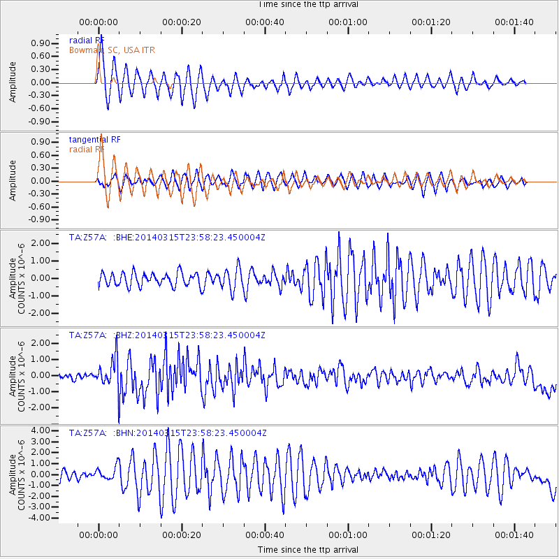
Signal To Noise
| Channel | StoN | STA | LTA |
| TA:Z57A: :BHZ:20140315T23:58:23.450004Z | 6.0405946 | 9.190907E-7 | 1.5215235E-7 |
| TA:Z57A: :BHN:20140315T23:58:23.450004Z | 1.3527606 | 6.1873214E-7 | 4.5738483E-7 |
| TA:Z57A: :BHE:20140315T23:58:23.450004Z | 1.7179519 | 6.2472293E-7 | 3.63644E-7 |
| Arrivals |
| Ps | 1.2 SECOND |
| PpPs | 4.2 SECOND |
| PsPs/PpSs | 5.4 SECOND |


