You are here: Home > Network List > US - United States National Seismic Network Stations List
> Station DGMT Dagmar, Montana, USA > Earthquake Result Viewer
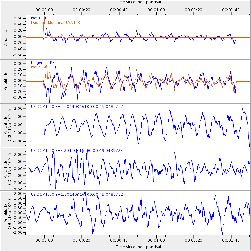
DGMT Dagmar, Montana, USA - Earthquake Result Viewer
*The percent match for this event was below the threshold and hence no stack was calculated.
| Earthquake location: |
Near Coast Of Northern Peru |
| Earthquake latitude/longitude: |
-5.6/-81.0 |
| Earthquake time(UTC): |
2014/03/15 (074) 23:51:33 GMT |
| Earthquake Depth: |
29 km |
| Earthquake Magnitude: |
6.3 MWW, 6.2 MWB, 6.3 MWC |
| Earthquake Catalog/Contributor: |
NEIC PDE/NEIC COMCAT |
|
| Network: |
US United States National Seismic Network |
| Station: |
DGMT Dagmar, Montana, USA |
| Lat/Lon: |
48.47 N/104.20 W |
| Elevation: |
0.0 m |
|
| Distance: |
57.6 deg |
| Az: |
341.87 deg |
| Baz: |
152.265 deg |
| Ray Param: |
$rayparam |
*The percent match for this event was below the threshold and hence was not used in the summary stack. |
|
| Radial Match: |
40.45826 % |
| Radial Bump: |
394 |
| Transverse Match: |
67.60387 % |
| Transverse Bump: |
400 |
| SOD ConfigId: |
626651 |
| Insert Time: |
2014-04-21 06:59:49.902 +0000 |
| GWidth: |
2.5 |
| Max Bumps: |
400 |
| Tol: |
0.001 |
|
Signal To Noise
| Channel | StoN | STA | LTA |
| US:DGMT:00:BHZ:20140316T00:00:49.048972Z | 3.7939088 | 1.2973198E-6 | 3.419481E-7 |
| US:DGMT:00:BH1:20140316T00:00:49.048972Z | 0.7209535 | 4.8142766E-7 | 6.677652E-7 |
| US:DGMT:00:BH2:20140316T00:00:49.048972Z | 1.4527963 | 8.5418634E-7 | 5.8796013E-7 |
| Arrivals |
| Ps | |
| PpPs | |
| PsPs/PpSs | |


