You are here: Home > Network List > US - United States National Seismic Network Stations List
> Station EGMT Eagleton, Montana, USA > Earthquake Result Viewer
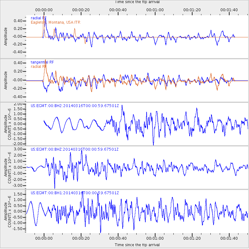
EGMT Eagleton, Montana, USA - Earthquake Result Viewer
*The percent match for this event was below the threshold and hence no stack was calculated.
| Earthquake location: |
Near Coast Of Northern Peru |
| Earthquake latitude/longitude: |
-5.6/-81.0 |
| Earthquake time(UTC): |
2014/03/15 (074) 23:51:33 GMT |
| Earthquake Depth: |
29 km |
| Earthquake Magnitude: |
6.3 MWW, 6.2 MWB, 6.3 MWC |
| Earthquake Catalog/Contributor: |
NEIC PDE/NEIC COMCAT |
|
| Network: |
US United States National Seismic Network |
| Station: |
EGMT Eagleton, Montana, USA |
| Lat/Lon: |
48.02 N/109.75 W |
| Elevation: |
1055 m |
|
| Distance: |
59.1 deg |
| Az: |
337.853 deg |
| Baz: |
146.018 deg |
| Ray Param: |
$rayparam |
*The percent match for this event was below the threshold and hence was not used in the summary stack. |
|
| Radial Match: |
75.44928 % |
| Radial Bump: |
400 |
| Transverse Match: |
66.14638 % |
| Transverse Bump: |
400 |
| SOD ConfigId: |
626651 |
| Insert Time: |
2014-04-21 06:59:59.693 +0000 |
| GWidth: |
2.5 |
| Max Bumps: |
400 |
| Tol: |
0.001 |
|
Signal To Noise
| Channel | StoN | STA | LTA |
| US:EGMT:00:BHZ:20140316T00:00:59.67501Z | 3.122187 | 6.960016E-7 | 2.229212E-7 |
| US:EGMT:00:BH1:20140316T00:00:59.67501Z | 0.6704593 | 2.3904897E-7 | 3.565451E-7 |
| US:EGMT:00:BH2:20140316T00:00:59.67501Z | 0.8262038 | 3.4434524E-7 | 4.1678E-7 |
| Arrivals |
| Ps | |
| PpPs | |
| PsPs/PpSs | |


