You are here: Home > Network List > UW - Pacific Northwest Regional Seismic Network Stations List
> Station UMAT Pilot Rock, OR, USA > Earthquake Result Viewer
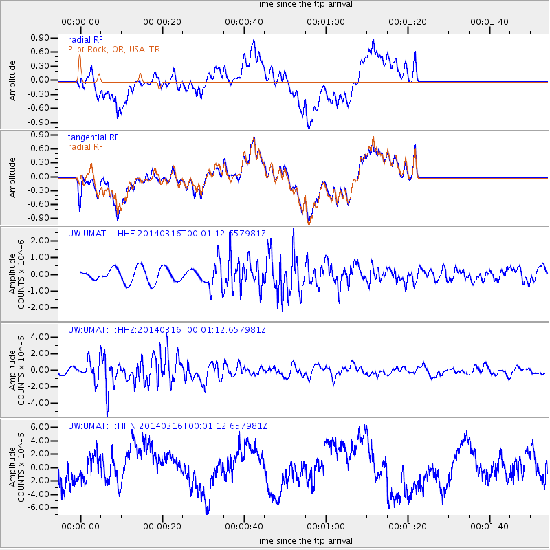
UMAT Pilot Rock, OR, USA - Earthquake Result Viewer
*The percent match for this event was below the threshold and hence no stack was calculated.
| Earthquake location: |
Near Coast Of Northern Peru |
| Earthquake latitude/longitude: |
-5.6/-81.0 |
| Earthquake time(UTC): |
2014/03/15 (074) 23:51:33 GMT |
| Earthquake Depth: |
29 km |
| Earthquake Magnitude: |
6.3 MWW, 6.2 MWB, 6.3 MWC |
| Earthquake Catalog/Contributor: |
NEIC PDE/NEIC COMCAT |
|
| Network: |
UW Pacific Northwest Regional Seismic Network |
| Station: |
UMAT Pilot Rock, OR, USA |
| Lat/Lon: |
45.29 N/118.96 W |
| Elevation: |
1318 m |
|
| Distance: |
61.0 deg |
| Az: |
330.195 deg |
| Baz: |
135.504 deg |
| Ray Param: |
$rayparam |
*The percent match for this event was below the threshold and hence was not used in the summary stack. |
|
| Radial Match: |
50.745502 % |
| Radial Bump: |
400 |
| Transverse Match: |
52.273426 % |
| Transverse Bump: |
400 |
| SOD ConfigId: |
626651 |
| Insert Time: |
2014-04-21 07:04:27.498 +0000 |
| GWidth: |
2.5 |
| Max Bumps: |
400 |
| Tol: |
0.001 |
|
Signal To Noise
| Channel | StoN | STA | LTA |
| UW:UMAT: :HHZ:20140316T00:01:12.657981Z | 2.150293 | 1.1729516E-6 | 5.4548445E-7 |
| UW:UMAT: :HHN:20140316T00:01:12.657981Z | 0.40820616 | 1.8373478E-6 | 4.501029E-6 |
| UW:UMAT: :HHE:20140316T00:01:12.657981Z | 1.8836789 | 7.7261717E-7 | 4.1016395E-7 |
| Arrivals |
| Ps | |
| PpPs | |
| PsPs/PpSs | |


