You are here: Home > Network List > CM - Red Sismologica Nacional de Columbia Stations List
> Station URI Uribia, Guajira, Columbia > Earthquake Result Viewer
URI Uribia, Guajira, Columbia - Earthquake Result Viewer
| Earthquake location: |
Near Coast Of Northern Chile |
| Earthquake latitude/longitude: |
-19.9/-70.6 |
| Earthquake time(UTC): |
2014/03/16 (075) 21:16:30 GMT |
| Earthquake Depth: |
20 km |
| Earthquake Magnitude: |
6.7 MWW, 6.7 MWC, 7.0 MI |
| Earthquake Catalog/Contributor: |
NEIC PDE/NEIC COMCAT |
|
| Network: |
CM Red Sismologica Nacional de Columbia |
| Station: |
URI Uribia, Guajira, Columbia |
| Lat/Lon: |
11.70 N/71.99 W |
| Elevation: |
68 m |
|
| Distance: |
31.5 deg |
| Az: |
357.442 deg |
| Baz: |
177.543 deg |
| Ray Param: |
0.07905033 |
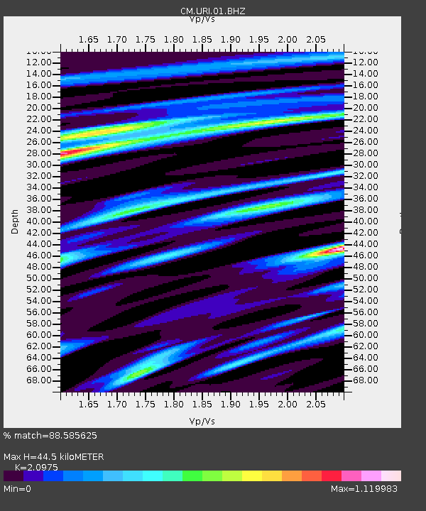
| Estimated Moho Depth: |
44.5 km |
| Estimated Crust Vp/Vs: |
2.10 |
| Assumed Crust Vp: |
5.738 km/s |
| Estimated Crust Vs: |
2.736 km/s |
| Estimated Crust Poisson's Ratio: |
0.35 |
|
| Radial Match: |
88.585625 % |
| Radial Bump: |
400 |
| Transverse Match: |
71.43101 % |
| Transverse Bump: |
400 |
| SOD ConfigId: |
626651 |
| Insert Time: |
2014-04-21 07:12:58.543 +0000 |
| GWidth: |
2.5 |
| Max Bumps: |
400 |
| Tol: |
0.001 |
|

Signal To Noise
| Channel | StoN | STA | LTA |
| CM:URI:01:BHZ:20140316T21:22:20.233013Z | 27.4816 | 2.6357784E-6 | 9.5910664E-8 |
| CM:URI:01:BHN:20140316T21:22:20.233013Z | 6.3652163 | 1.6115066E-6 | 2.5317388E-7 |
| CM:URI:01:BHE:20140316T21:22:20.233013Z | 1.2683375 | 4.7163132E-7 | 3.7185E-7 |
| Arrivals |
| Ps | 9.0 SECOND |
| PpPs | 23 SECOND |
| PsPs/PpSs | 32 SECOND |


