You are here: Home > Network List > GH - Ghana Digital Seismic Network Stations List
> Station WEIJ Weija Dam, Ghana > Earthquake Result Viewer
WEIJ Weija Dam, Ghana - Earthquake Result Viewer
| Earthquake location: |
Near Coast Of Northern Chile |
| Earthquake latitude/longitude: |
-19.9/-70.6 |
| Earthquake time(UTC): |
2014/03/16 (075) 21:16:30 GMT |
| Earthquake Depth: |
20 km |
| Earthquake Magnitude: |
6.7 MWW, 6.7 MWC, 7.0 MI |
| Earthquake Catalog/Contributor: |
NEIC PDE/NEIC COMCAT |
|
| Network: |
GH Ghana Digital Seismic Network |
| Station: |
WEIJ Weija Dam, Ghana |
| Lat/Lon: |
5.59 N/0.33 W |
| Elevation: |
203 m |
|
| Distance: |
73.6 deg |
| Az: |
77.676 deg |
| Baz: |
247.447 deg |
| Ray Param: |
0.052902516 |
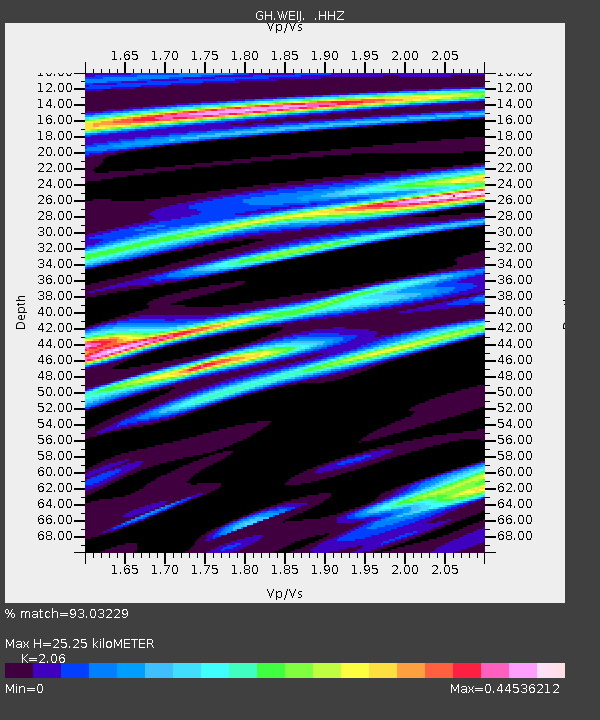
| Estimated Moho Depth: |
25.25 km |
| Estimated Crust Vp/Vs: |
2.06 |
| Assumed Crust Vp: |
6.472 km/s |
| Estimated Crust Vs: |
3.142 km/s |
| Estimated Crust Poisson's Ratio: |
0.35 |
|
| Radial Match: |
93.03229 % |
| Radial Bump: |
334 |
| Transverse Match: |
78.85168 % |
| Transverse Bump: |
400 |
| SOD ConfigId: |
626651 |
| Insert Time: |
2014-04-21 07:17:29.145 +0000 |
| GWidth: |
2.5 |
| Max Bumps: |
400 |
| Tol: |
0.001 |
|

Signal To Noise
| Channel | StoN | STA | LTA |
| GH:WEIJ: :HHZ:20140316T21:27:31.04002Z | 19.5515 | 3.177345E-6 | 1.6251157E-7 |
| GH:WEIJ: :HHN:20140316T21:27:31.04002Z | 2.7726138 | 5.7034487E-7 | 2.0570656E-7 |
| GH:WEIJ: :HHE:20140316T21:27:31.04002Z | 8.432914 | 1.3445723E-6 | 1.5944337E-7 |
| Arrivals |
| Ps | 4.3 SECOND |
| PpPs | 12 SECOND |
| PsPs/PpSs | 16 SECOND |


