You are here: Home > Network List > II - Global Seismograph Network (GSN - IRIS/IDA) Stations List
> Station EFI Mount Kent, East Falkland Island > Earthquake Result Viewer
EFI Mount Kent, East Falkland Island - Earthquake Result Viewer

| Earthquake location: |
Near Coast Of Northern Chile |
| Earthquake latitude/longitude: |
-19.9/-70.6 |
| Earthquake time(UTC): |
2014/03/16 (075) 21:16:30 GMT |
| Earthquake Depth: |
20 km |
| Earthquake Magnitude: |
6.7 MWW, 6.7 MWC, 7.0 MI |
| Earthquake Catalog/Contributor: |
NEIC PDE/NEIC COMCAT |
|
| Network: |
II Global Seismograph Network (GSN - IRIS/IDA) |
| Station: |
EFI Mount Kent, East Falkland Island |
| Lat/Lon: |
51.68 S/58.06 W |
| Elevation: |
110 m |
|
| Distance: |
33.2 deg |
| Az: |
165.672 deg |
| Baz: |
338.042 deg |
| Ray Param: |
0.0783028 |
| Estimated Moho Depth: |
36.5 km |
| Estimated Crust Vp/Vs: |
1.81 |
| Assumed Crust Vp: |
6.472 km/s |
| Estimated Crust Vs: |
3.571 km/s |
| Estimated Crust Poisson's Ratio: |
0.28 |
|
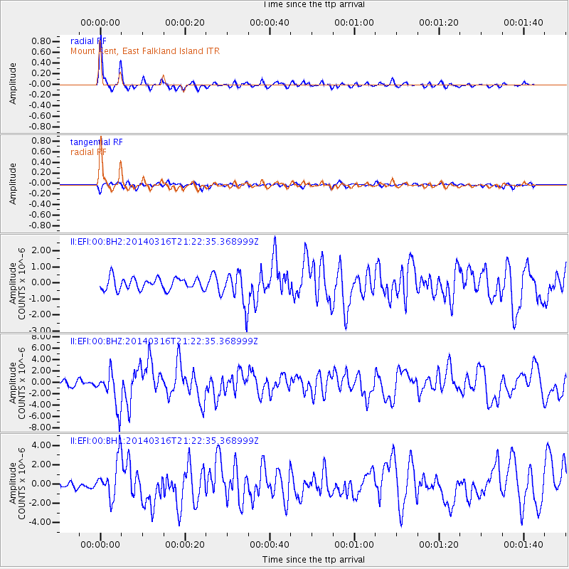
| Radial Match: |
86.53691 % |
| Radial Bump: |
321 |
| Transverse Match: |
70.38092 % |
| Transverse Bump: |
400 |
| SOD ConfigId: |
626651 |
| Insert Time: |
2014-04-21 07:18:33.388 +0000 |
| GWidth: |
2.5 |
| Max Bumps: |
400 |
| Tol: |
0.001 |
|
Signal To Noise
| Channel | StoN | STA | LTA |
| II:EFI:00:BHZ:20140316T21:22:35.368999Z | 6.0553994 | 3.2133778E-6 | 5.306632E-7 |
| II:EFI:00:BH1:20140316T21:22:35.368999Z | 5.254187 | 2.0464402E-6 | 3.894875E-7 |
| II:EFI:00:BH2:20140316T21:22:35.368999Z | 2.9652672 | 1.0764735E-6 | 3.6302748E-7 |
| Arrivals |
| Ps | 5.0 SECOND |
| PpPs | 15 SECOND |
| PsPs/PpSs | 20 SECOND |


