You are here: Home > Network List > IU - Global Seismograph Network (GSN - IRIS/USGS) Stations List
> Station TEIG Tepich, Yucatan, Mexico > Earthquake Result Viewer
TEIG Tepich, Yucatan, Mexico - Earthquake Result Viewer
| Earthquake location: |
Near Coast Of Northern Chile |
| Earthquake latitude/longitude: |
-19.9/-70.6 |
| Earthquake time(UTC): |
2014/03/16 (075) 21:16:30 GMT |
| Earthquake Depth: |
20 km |
| Earthquake Magnitude: |
6.7 MWW, 6.7 MWC, 7.0 MI |
| Earthquake Catalog/Contributor: |
NEIC PDE/NEIC COMCAT |
|
| Network: |
IU Global Seismograph Network (GSN - IRIS/USGS) |
| Station: |
TEIG Tepich, Yucatan, Mexico |
| Lat/Lon: |
20.23 N/88.28 W |
| Elevation: |
40 m |
|
| Distance: |
43.5 deg |
| Az: |
335.562 deg |
| Baz: |
155.512 deg |
| Ray Param: |
0.07249474 |
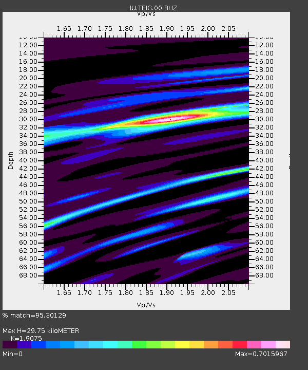
| Estimated Moho Depth: |
29.75 km |
| Estimated Crust Vp/Vs: |
1.91 |
| Assumed Crust Vp: |
5.817 km/s |
| Estimated Crust Vs: |
3.05 km/s |
| Estimated Crust Poisson's Ratio: |
0.31 |
|
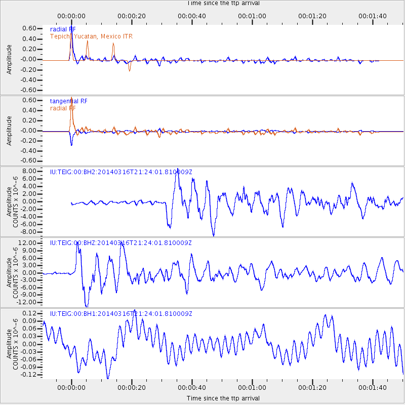
| Radial Match: |
95.30129 % |
| Radial Bump: |
262 |
| Transverse Match: |
94.904495 % |
| Transverse Bump: |
268 |
| SOD ConfigId: |
626651 |
| Insert Time: |
2014-04-21 07:19:42.456 +0000 |
| GWidth: |
2.5 |
| Max Bumps: |
400 |
| Tol: |
0.001 |
|
Signal To Noise
| Channel | StoN | STA | LTA |
| IU:TEIG:00:BHZ:20140316T21:24:01.810009Z | 22.536959 | 6.9074586E-6 | 3.064947E-7 |
| IU:TEIG:00:BH1:20140316T21:24:01.810009Z | 0.30119228 | 3.256385E-8 | 1.0811648E-7 |
| IU:TEIG:00:BH2:20140316T21:24:01.810009Z | 12.672244 | 3.8050462E-6 | 3.0026618E-7 |
| Arrivals |
| Ps | 4.9 SECOND |
| PpPs | 14 SECOND |
| PsPs/PpSs | 19 SECOND |


