You are here: Home > Network List > N4 - Central and EAstern US Network Stations List
> Station 060A Indiantown, FL, USA > Earthquake Result Viewer
060A Indiantown, FL, USA - Earthquake Result Viewer
| Earthquake location: |
Near Coast Of Northern Chile |
| Earthquake latitude/longitude: |
-19.9/-70.6 |
| Earthquake time(UTC): |
2014/03/16 (075) 21:16:30 GMT |
| Earthquake Depth: |
20 km |
| Earthquake Magnitude: |
6.7 MWW, 6.7 MWC, 7.0 MI |
| Earthquake Catalog/Contributor: |
NEIC PDE/NEIC COMCAT |
|
| Network: |
N4 Central and EAstern US Network |
| Station: |
060A Indiantown, FL, USA |
| Lat/Lon: |
27.04 N/80.36 W |
| Elevation: |
9.0 m |
|
| Distance: |
47.6 deg |
| Az: |
348.221 deg |
| Baz: |
167.565 deg |
| Ray Param: |
0.06984363 |
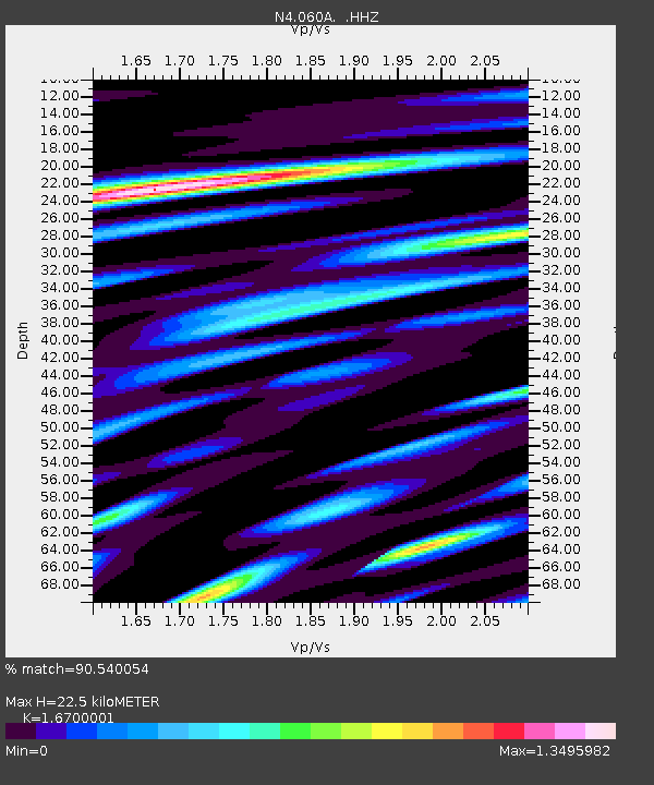
| Estimated Moho Depth: |
22.5 km |
| Estimated Crust Vp/Vs: |
1.67 |
| Assumed Crust Vp: |
6.347 km/s |
| Estimated Crust Vs: |
3.801 km/s |
| Estimated Crust Poisson's Ratio: |
0.22 |
|
| Radial Match: |
90.540054 % |
| Radial Bump: |
400 |
| Transverse Match: |
50.391964 % |
| Transverse Bump: |
400 |
| SOD ConfigId: |
626651 |
| Insert Time: |
2014-04-21 07:22:03.558 +0000 |
| GWidth: |
2.5 |
| Max Bumps: |
400 |
| Tol: |
0.001 |
|

Signal To Noise
| Channel | StoN | STA | LTA |
| N4:060A: :HHZ:20140316T21:24:34.50999Z | 10.198119 | 6.3910525E-6 | 6.266893E-7 |
| N4:060A: :HHN:20140316T21:24:34.50999Z | 3.2414086 | 3.9702804E-6 | 1.2248626E-6 |
| N4:060A: :HHE:20140316T21:24:34.50999Z | 1.6692239 | 2.2210743E-6 | 1.330603E-6 |
| Arrivals |
| Ps | 2.5 SECOND |
| PpPs | 8.9 SECOND |
| PsPs/PpSs | 11 SECOND |


