You are here: Home > Network List > N4 - Central and EAstern US Network Stations List
> Station 154A Montrose, GA, USA > Earthquake Result Viewer
154A Montrose, GA, USA - Earthquake Result Viewer
| Earthquake location: |
Near Coast Of Northern Chile |
| Earthquake latitude/longitude: |
-19.9/-70.6 |
| Earthquake time(UTC): |
2014/03/16 (075) 21:16:30 GMT |
| Earthquake Depth: |
20 km |
| Earthquake Magnitude: |
6.7 MWW, 6.7 MWC, 7.0 MI |
| Earthquake Catalog/Contributor: |
NEIC PDE/NEIC COMCAT |
|
| Network: |
N4 Central and EAstern US Network |
| Station: |
154A Montrose, GA, USA |
| Lat/Lon: |
32.61 N/83.11 W |
| Elevation: |
111 m |
|
| Distance: |
53.6 deg |
| Az: |
346.903 deg |
| Baz: |
165.367 deg |
| Ray Param: |
0.065974586 |
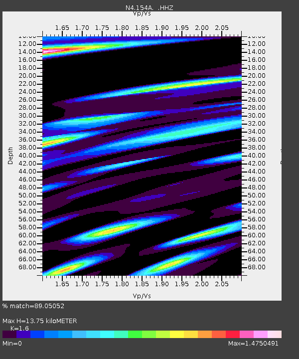
| Estimated Moho Depth: |
13.75 km |
| Estimated Crust Vp/Vs: |
1.60 |
| Assumed Crust Vp: |
6.565 km/s |
| Estimated Crust Vs: |
4.103 km/s |
| Estimated Crust Poisson's Ratio: |
0.18 |
|
| Radial Match: |
89.05052 % |
| Radial Bump: |
355 |
| Transverse Match: |
73.83 % |
| Transverse Bump: |
400 |
| SOD ConfigId: |
626651 |
| Insert Time: |
2014-04-21 07:22:13.285 +0000 |
| GWidth: |
2.5 |
| Max Bumps: |
400 |
| Tol: |
0.001 |
|

Signal To Noise
| Channel | StoN | STA | LTA |
| N4:154A: :HHZ:20140316T21:25:19.420024Z | 29.67514 | 6.278048E-6 | 2.1155917E-7 |
| N4:154A: :HHN:20140316T21:25:19.420024Z | 6.484543 | 3.7563689E-6 | 5.792804E-7 |
| N4:154A: :HHE:20140316T21:25:19.420024Z | 1.56751 | 9.3806676E-7 | 5.984439E-7 |
| Arrivals |
| Ps | 1.3 SECOND |
| PpPs | 5.1 SECOND |
| PsPs/PpSs | 6.5 SECOND |


