You are here: Home > Network List > N4 - Central and EAstern US Network Stations List
> Station R32B Long Quarter, Great Bend, KS, USA > Earthquake Result Viewer
R32B Long Quarter, Great Bend, KS, USA - Earthquake Result Viewer
| Earthquake location: |
Near Coast Of Northern Chile |
| Earthquake latitude/longitude: |
-19.9/-70.6 |
| Earthquake time(UTC): |
2014/03/16 (075) 21:16:30 GMT |
| Earthquake Depth: |
20 km |
| Earthquake Magnitude: |
6.7 MWW, 6.7 MWC, 7.0 MI |
| Earthquake Catalog/Contributor: |
NEIC PDE/NEIC COMCAT |
|
| Network: |
N4 Central and EAstern US Network |
| Station: |
R32B Long Quarter, Great Bend, KS, USA |
| Lat/Lon: |
38.42 N/98.71 W |
| Elevation: |
568 m |
|
| Distance: |
63.7 deg |
| Az: |
335.651 deg |
| Baz: |
150.405 deg |
| Ray Param: |
0.059355307 |
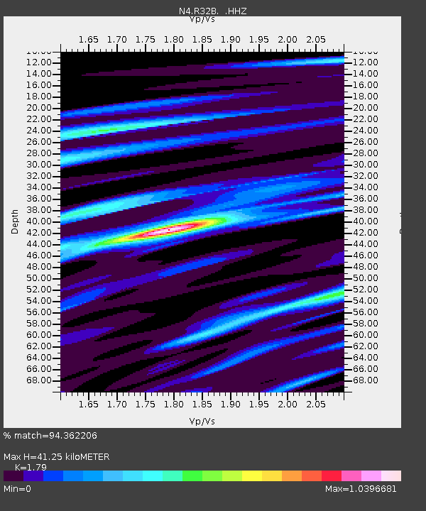
| Estimated Moho Depth: |
41.25 km |
| Estimated Crust Vp/Vs: |
1.79 |
| Assumed Crust Vp: |
6.483 km/s |
| Estimated Crust Vs: |
3.622 km/s |
| Estimated Crust Poisson's Ratio: |
0.27 |
|
| Radial Match: |
94.362206 % |
| Radial Bump: |
326 |
| Transverse Match: |
78.32633 % |
| Transverse Bump: |
400 |
| SOD ConfigId: |
626651 |
| Insert Time: |
2014-04-21 07:23:57.156 +0000 |
| GWidth: |
2.5 |
| Max Bumps: |
400 |
| Tol: |
0.001 |
|

Signal To Noise
| Channel | StoN | STA | LTA |
| N4:R32B: :HHZ:20140316T21:26:29.980022Z | 15.697149 | 4.180201E-6 | 2.6630318E-7 |
| N4:R32B: :HHN:20140316T21:26:29.980022Z | 12.918578 | 1.9598938E-6 | 1.5171128E-7 |
| N4:R32B: :HHE:20140316T21:26:29.980022Z | 7.7007475 | 1.090922E-6 | 1.4166443E-7 |
| Arrivals |
| Ps | 5.3 SECOND |
| PpPs | 17 SECOND |
| PsPs/PpSs | 22 SECOND |


