You are here: Home > Network List > NE - New England Seismic Network Stations List
> Station PQI Presque Isle, ME, USA > Earthquake Result Viewer
PQI Presque Isle, ME, USA - Earthquake Result Viewer

| Earthquake location: |
Near Coast Of Northern Chile |
| Earthquake latitude/longitude: |
-19.9/-70.6 |
| Earthquake time(UTC): |
2014/03/16 (075) 21:16:30 GMT |
| Earthquake Depth: |
20 km |
| Earthquake Magnitude: |
6.7 MWW, 6.7 MWC, 7.0 MI |
| Earthquake Catalog/Contributor: |
NEIC PDE/NEIC COMCAT |
|
| Network: |
NE New England Seismic Network |
| Station: |
PQI Presque Isle, ME, USA |
| Lat/Lon: |
46.67 N/68.02 W |
| Elevation: |
162 m |
|
| Distance: |
66.3 deg |
| Az: |
1.961 deg |
| Baz: |
182.68 deg |
| Ray Param: |
0.05767077 |
| Estimated Moho Depth: |
21.5 km |
| Estimated Crust Vp/Vs: |
1.64 |
| Assumed Crust Vp: |
6.419 km/s |
| Estimated Crust Vs: |
3.92 km/s |
| Estimated Crust Poisson's Ratio: |
0.20 |
|
| Radial Match: |
81.317184 % |
| Radial Bump: |
400 |
| Transverse Match: |
73.23999 % |
| Transverse Bump: |
400 |
| SOD ConfigId: |
626651 |
| Insert Time: |
2014-04-21 07:25:19.840 +0000 |
| GWidth: |
2.5 |
| Max Bumps: |
400 |
| Tol: |
0.001 |
|
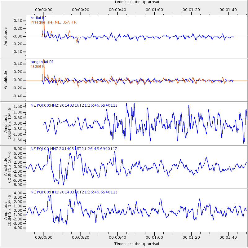
Signal To Noise
| Channel | StoN | STA | LTA |
| NE:PQI:00:HHZ:20140316T21:26:46.694011Z | 5.949968 | 3.6644976E-6 | 6.1588526E-7 |
| NE:PQI:00:HH1:20140316T21:26:46.694011Z | 4.571811 | 1.7816674E-6 | 3.897071E-7 |
| NE:PQI:00:HH2:20140316T21:26:46.694011Z | 1.4168329 | 4.8646257E-7 | 3.4334505E-7 |
| Arrivals |
| Ps | 2.2 SECOND |
| PpPs | 8.5 SECOND |
| PsPs/PpSs | 11 SECOND |


