You are here: Home > Network List > NM - Cooperative New Madrid Seismic Network Stations List
> Station UTMT Martin, TN > Earthquake Result Viewer
UTMT Martin, TN - Earthquake Result Viewer
| Earthquake location: |
Near Coast Of Northern Chile |
| Earthquake latitude/longitude: |
-19.9/-70.6 |
| Earthquake time(UTC): |
2014/03/16 (075) 21:16:30 GMT |
| Earthquake Depth: |
20 km |
| Earthquake Magnitude: |
6.7 MWW, 6.7 MWC, 7.0 MI |
| Earthquake Catalog/Contributor: |
NEIC PDE/NEIC COMCAT |
|
| Network: |
NM Cooperative New Madrid Seismic Network |
| Station: |
UTMT Martin, TN |
| Lat/Lon: |
36.35 N/88.86 W |
| Elevation: |
110 m |
|
| Distance: |
58.6 deg |
| Az: |
342.778 deg |
| Baz: |
159.814 deg |
| Ray Param: |
0.06273775 |
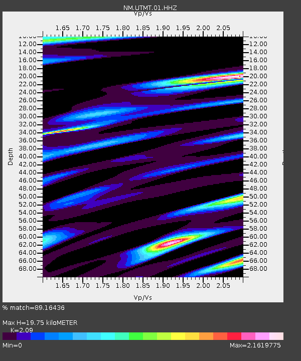
| Estimated Moho Depth: |
19.75 km |
| Estimated Crust Vp/Vs: |
2.09 |
| Assumed Crust Vp: |
6.444 km/s |
| Estimated Crust Vs: |
3.083 km/s |
| Estimated Crust Poisson's Ratio: |
0.35 |
|
| Radial Match: |
89.16436 % |
| Radial Bump: |
389 |
| Transverse Match: |
71.97967 % |
| Transverse Bump: |
400 |
| SOD ConfigId: |
626651 |
| Insert Time: |
2014-04-21 07:26:34.864 +0000 |
| GWidth: |
2.5 |
| Max Bumps: |
400 |
| Tol: |
0.001 |
|
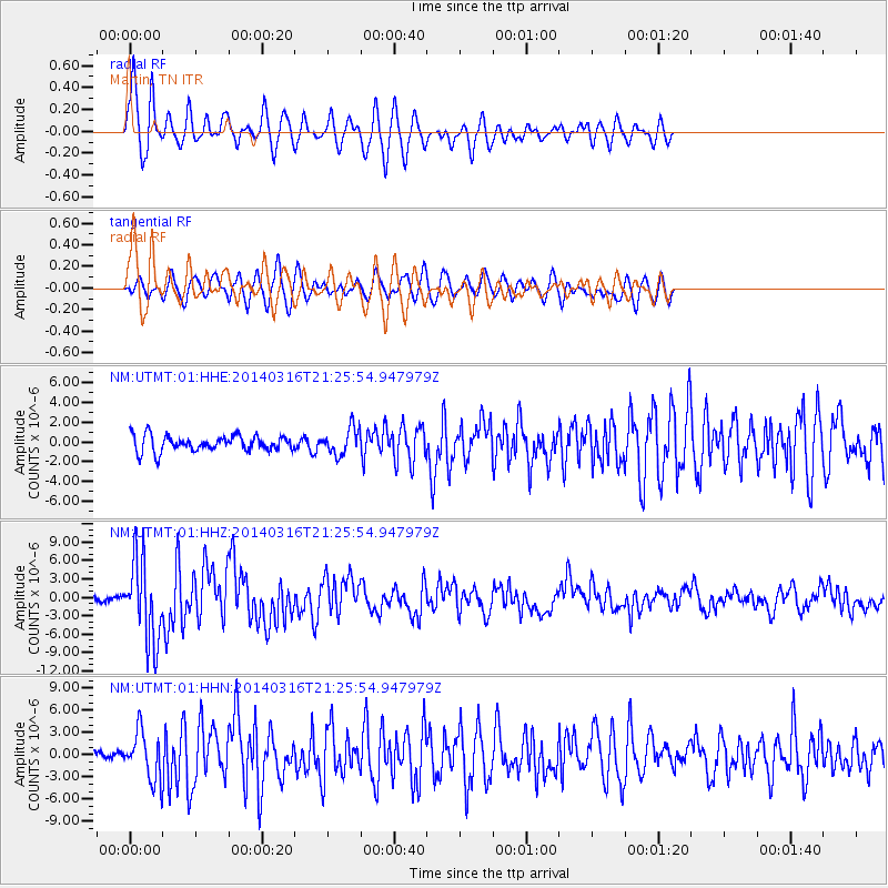
Signal To Noise
| Channel | StoN | STA | LTA |
| NM:UTMT:01:HHZ:20140316T21:25:54.947979Z | 20.41919 | 6.678727E-6 | 3.270809E-7 |
| NM:UTMT:01:HHN:20140316T21:25:54.947979Z | 4.262907 | 3.1447207E-6 | 7.37694E-7 |
| NM:UTMT:01:HHE:20140316T21:25:54.947979Z | 1.6782575 | 1.3446254E-6 | 8.012033E-7 |
| Arrivals |
| Ps | 3.5 SECOND |
| PpPs | 9.1 SECOND |
| PsPs/PpSs | 13 SECOND |


