You are here: Home > Network List > NN - Western Great Basin/Eastern Sierra Nevada Stations List
> Station SHP Sheep Range, Nevada w84gm > Earthquake Result Viewer
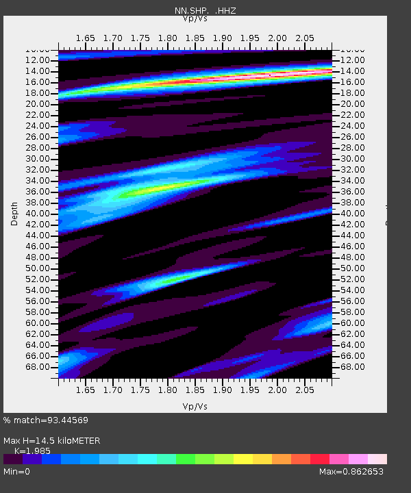
SHP Sheep Range, Nevada w84gm - Earthquake Result Viewer
| Earthquake location: |
Near Coast Of Northern Chile |
| Earthquake latitude/longitude: |
-19.9/-70.6 |
| Earthquake time(UTC): |
2014/03/16 (075) 21:16:30 GMT |
| Earthquake Depth: |
20 km |
| Earthquake Magnitude: |
6.7 MWW, 6.7 MWC, 7.0 MI |
| Earthquake Catalog/Contributor: |
NEIC PDE/NEIC COMCAT |
|
| Network: |
NN Western Great Basin/Eastern Sierra Nevada |
| Station: |
SHP Sheep Range, Nevada w84gm |
| Lat/Lon: |
36.50 N/115.16 W |
| Elevation: |
1632 m |
|
| Distance: |
70.1 deg |
| Az: |
323.075 deg |
| Baz: |
135.449 deg |
| Ray Param: |
0.05516245 |
| Estimated Moho Depth: |
14.5 km |
| Estimated Crust Vp/Vs: |
1.99 |
| Assumed Crust Vp: |
6.276 km/s |
| Estimated Crust Vs: |
3.162 km/s |
| Estimated Crust Poisson's Ratio: |
0.33 |
|
| Radial Match: |
93.44569 % |
| Radial Bump: |
312 |
| Transverse Match: |
73.93531 % |
| Transverse Bump: |
400 |
| SOD ConfigId: |
626651 |
| Insert Time: |
2014-04-21 07:27:02.890 +0000 |
| GWidth: |
2.5 |
| Max Bumps: |
400 |
| Tol: |
0.001 |
|

Signal To Noise
| Channel | StoN | STA | LTA |
| NN:SHP: :HHZ:20140316T21:27:10.535015Z | 9.781071 | 2.7861654E-6 | 2.848528E-7 |
| NN:SHP: :HHN:20140316T21:27:10.535015Z | 4.4892654 | 1.1160942E-6 | 2.48614E-7 |
| NN:SHP: :HHE:20140316T21:27:10.535015Z | 3.7284524 | 9.89087E-7 | 2.6528082E-7 |
| Arrivals |
| Ps | 2.3 SECOND |
| PpPs | 6.7 SECOND |
| PsPs/PpSs | 9.0 SECOND |


