You are here: Home > Network List > TA - USArray Transportable Network (new EarthScope stations) Stations List
> Station A21K Barrow, AK, USA > Earthquake Result Viewer
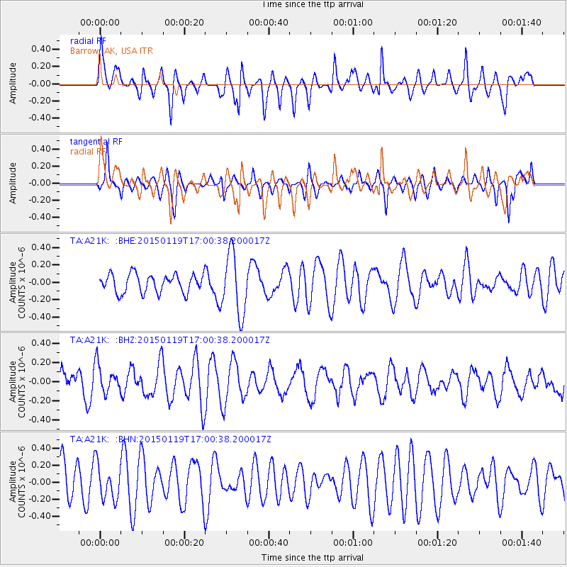
A21K Barrow, AK, USA - Earthquake Result Viewer
*The percent match for this event was below the threshold and hence no stack was calculated.
| Earthquake location: |
Southeast Of Loyalty Islands |
| Earthquake latitude/longitude: |
-22.2/174.9 |
| Earthquake time(UTC): |
2015/01/19 (019) 16:47:48 GMT |
| Earthquake Depth: |
35 km |
| Earthquake Magnitude: |
4.4 mb, 3.7 mb |
| Earthquake Catalog/Contributor: |
ISC/ISC |
|
| Network: |
TA USArray Transportable Network (new EarthScope stations) |
| Station: |
A21K Barrow, AK, USA |
| Lat/Lon: |
71.32 N/156.62 W |
| Elevation: |
577 m |
|
| Distance: |
95.4 deg |
| Az: |
8.871 deg |
| Baz: |
206.324 deg |
| Ray Param: |
$rayparam |
*The percent match for this event was below the threshold and hence was not used in the summary stack. |
|
| Radial Match: |
57.373863 % |
| Radial Bump: |
400 |
| Transverse Match: |
47.648655 % |
| Transverse Bump: |
400 |
| SOD ConfigId: |
3390531 |
| Insert Time: |
2019-04-16 03:02:09.017 +0000 |
| GWidth: |
2.5 |
| Max Bumps: |
400 |
| Tol: |
0.001 |
|
Signal To Noise
| Channel | StoN | STA | LTA |
| TA:A21K: :BHZ:20150119T17:00:38.200017Z | 0.669336 | 1.408418E-7 | 2.1042017E-7 |
| TA:A21K: :BHN:20150119T17:00:38.200017Z | 0.80538225 | 1.950041E-7 | 2.4212613E-7 |
| TA:A21K: :BHE:20150119T17:00:38.200017Z | 3.4143505 | 3.5866725E-7 | 1.0504699E-7 |
| Arrivals |
| Ps | |
| PpPs | |
| PsPs/PpSs | |


