You are here: Home > Network List > PE - Penn State Network Stations List
> Station PSUB Penn State - Brandywine Campus > Earthquake Result Viewer
PSUB Penn State - Brandywine Campus - Earthquake Result Viewer
| Earthquake location: |
Near Coast Of Northern Chile |
| Earthquake latitude/longitude: |
-19.9/-70.6 |
| Earthquake time(UTC): |
2014/03/16 (075) 21:16:30 GMT |
| Earthquake Depth: |
20 km |
| Earthquake Magnitude: |
6.7 MWW, 6.7 MWC, 7.0 MI |
| Earthquake Catalog/Contributor: |
NEIC PDE/NEIC COMCAT |
|
| Network: |
PE Penn State Network |
| Station: |
PSUB Penn State - Brandywine Campus |
| Lat/Lon: |
39.93 N/75.45 W |
| Elevation: |
110 m |
|
| Distance: |
59.7 deg |
| Az: |
355.705 deg |
| Baz: |
174.743 deg |
| Ray Param: |
0.061986733 |
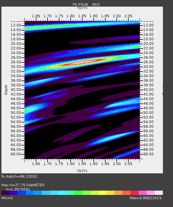
| Estimated Moho Depth: |
27.75 km |
| Estimated Crust Vp/Vs: |
1.86 |
| Assumed Crust Vp: |
6.287 km/s |
| Estimated Crust Vs: |
3.385 km/s |
| Estimated Crust Poisson's Ratio: |
0.30 |
|
| Radial Match: |
96.33052 % |
| Radial Bump: |
335 |
| Transverse Match: |
70.60357 % |
| Transverse Bump: |
400 |
| SOD ConfigId: |
626651 |
| Insert Time: |
2014-04-21 07:28:18.759 +0000 |
| GWidth: |
2.5 |
| Max Bumps: |
400 |
| Tol: |
0.001 |
|
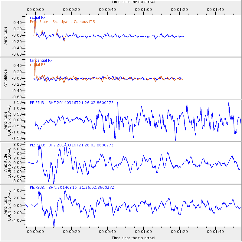
Signal To Noise
| Channel | StoN | STA | LTA |
| PE:PSUB: :BHZ:20140316T21:26:02.860027Z | 17.731005 | 4.005437E-6 | 2.2590017E-7 |
| PE:PSUB: :BHN:20140316T21:26:02.860027Z | 8.894935 | 1.9478903E-6 | 2.1898873E-7 |
| PE:PSUB: :BHE:20140316T21:26:02.860027Z | 1.2651911 | 3.452646E-7 | 2.7289522E-7 |
| Arrivals |
| Ps | 4.0 SECOND |
| PpPs | 12 SECOND |
| PsPs/PpSs | 16 SECOND |


