You are here: Home > Network List > TA - USArray Transportable Network (new EarthScope stations) Stations List
> Station 109C Camp Elliot, Mirimar, CA, USA > Earthquake Result Viewer
109C Camp Elliot, Mirimar, CA, USA - Earthquake Result Viewer

| Earthquake location: |
Near Coast Of Northern Chile |
| Earthquake latitude/longitude: |
-19.9/-70.6 |
| Earthquake time(UTC): |
2014/03/16 (075) 21:16:30 GMT |
| Earthquake Depth: |
20 km |
| Earthquake Magnitude: |
6.7 MWW, 6.7 MWC, 7.0 MI |
| Earthquake Catalog/Contributor: |
NEIC PDE/NEIC COMCAT |
|
| Network: |
TA USArray Transportable Network (new EarthScope stations) |
| Station: |
109C Camp Elliot, Mirimar, CA, USA |
| Lat/Lon: |
32.89 N/117.11 W |
| Elevation: |
150 m |
|
| Distance: |
68.8 deg |
| Az: |
319.119 deg |
| Baz: |
132.955 deg |
| Ray Param: |
0.056064527 |
| Estimated Moho Depth: |
27.5 km |
| Estimated Crust Vp/Vs: |
1.96 |
| Assumed Crust Vp: |
6.264 km/s |
| Estimated Crust Vs: |
3.2 km/s |
| Estimated Crust Poisson's Ratio: |
0.32 |
|
| Radial Match: |
93.74549 % |
| Radial Bump: |
400 |
| Transverse Match: |
82.6569 % |
| Transverse Bump: |
400 |
| SOD ConfigId: |
626651 |
| Insert Time: |
2014-04-21 07:30:58.225 +0000 |
| GWidth: |
2.5 |
| Max Bumps: |
400 |
| Tol: |
0.001 |
|
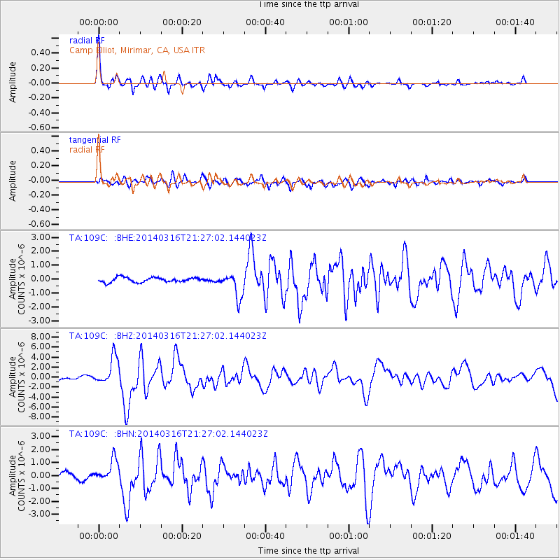
Signal To Noise
| Channel | StoN | STA | LTA |
| TA:109C: :BHZ:20140316T21:27:02.144023Z | 9.374505 | 2.903739E-6 | 3.097485E-7 |
| TA:109C: :BHN:20140316T21:27:02.144023Z | 2.3477402 | 9.086569E-7 | 3.8703467E-7 |
| TA:109C: :BHE:20140316T21:27:02.144023Z | 5.535472 | 9.3600164E-7 | 1.6909156E-7 |
| Arrivals |
| Ps | 4.3 SECOND |
| PpPs | 13 SECOND |
| PsPs/PpSs | 17 SECOND |


