You are here: Home > Network List > TA - USArray Transportable Network (new EarthScope stations) Stations List
> Station A04D Lummi Island, WA, USA > Earthquake Result Viewer
A04D Lummi Island, WA, USA - Earthquake Result Viewer
| Earthquake location: |
Near Coast Of Northern Chile |
| Earthquake latitude/longitude: |
-19.9/-70.6 |
| Earthquake time(UTC): |
2014/03/16 (075) 21:16:30 GMT |
| Earthquake Depth: |
20 km |
| Earthquake Magnitude: |
6.7 MWW, 6.7 MWC, 7.0 MI |
| Earthquake Catalog/Contributor: |
NEIC PDE/NEIC COMCAT |
|
| Network: |
TA USArray Transportable Network (new EarthScope stations) |
| Station: |
A04D Lummi Island, WA, USA |
| Lat/Lon: |
48.72 N/122.71 W |
| Elevation: |
13 m |
|
| Distance: |
82.6 deg |
| Az: |
328.209 deg |
| Baz: |
131.542 deg |
| Ray Param: |
0.04676936 |
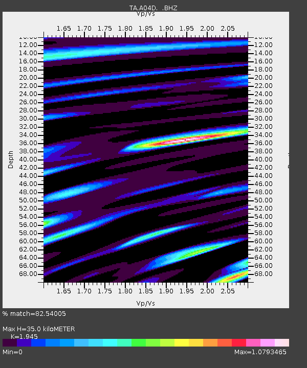
| Estimated Moho Depth: |
35.0 km |
| Estimated Crust Vp/Vs: |
1.95 |
| Assumed Crust Vp: |
6.566 km/s |
| Estimated Crust Vs: |
3.376 km/s |
| Estimated Crust Poisson's Ratio: |
0.32 |
|
| Radial Match: |
82.54005 % |
| Radial Bump: |
400 |
| Transverse Match: |
72.038475 % |
| Transverse Bump: |
400 |
| SOD ConfigId: |
626651 |
| Insert Time: |
2014-04-21 07:31:14.362 +0000 |
| GWidth: |
2.5 |
| Max Bumps: |
400 |
| Tol: |
0.001 |
|
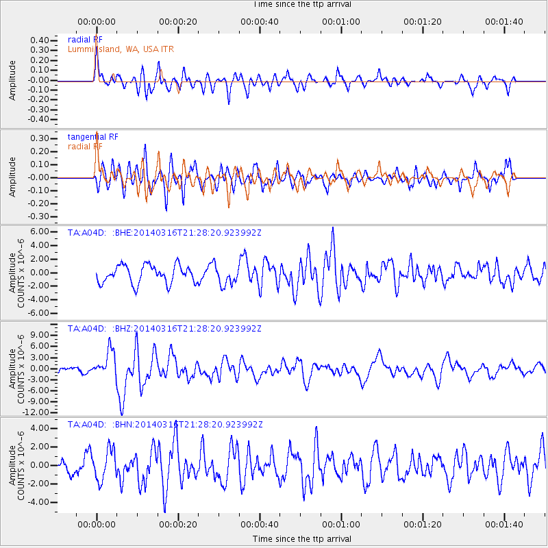
Signal To Noise
| Channel | StoN | STA | LTA |
| TA:A04D: :BHZ:20140316T21:28:20.923992Z | 5.1914797 | 3.6927474E-6 | 7.113092E-7 |
| TA:A04D: :BHN:20140316T21:28:20.923992Z | 1.5188047 | 1.6611451E-6 | 1.0937188E-6 |
| TA:A04D: :BHE:20140316T21:28:20.923992Z | 1.0242745 | 1.3511727E-6 | 1.319151E-6 |
| Arrivals |
| Ps | 5.2 SECOND |
| PpPs | 15 SECOND |
| PsPs/PpSs | 20 SECOND |


