You are here: Home > Network List > TA - USArray Transportable Network (new EarthScope stations) Stations List
> Station D48A Paudash Township, ON, CAN > Earthquake Result Viewer
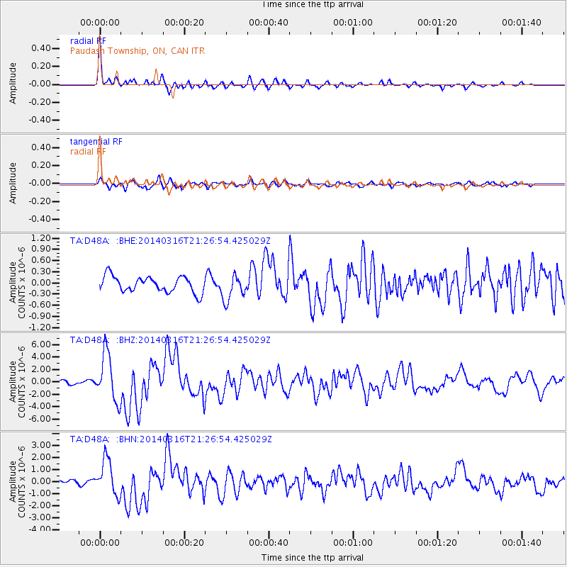
D48A Paudash Township, ON, CAN - Earthquake Result Viewer

| Earthquake location: |
Near Coast Of Northern Chile |
| Earthquake latitude/longitude: |
-19.9/-70.6 |
| Earthquake time(UTC): |
2014/03/16 (075) 21:16:30 GMT |
| Earthquake Depth: |
20 km |
| Earthquake Magnitude: |
6.7 MWW, 6.7 MWC, 7.0 MI |
| Earthquake Catalog/Contributor: |
NEIC PDE/NEIC COMCAT |
|
| Network: |
TA USArray Transportable Network (new EarthScope stations) |
| Station: |
D48A Paudash Township, ON, CAN |
| Lat/Lon: |
47.17 N/81.81 W |
| Elevation: |
434 m |
|
| Distance: |
67.5 deg |
| Az: |
351.771 deg |
| Baz: |
168.616 deg |
| Ray Param: |
0.056868564 |
| Estimated Moho Depth: |
37.75 km |
| Estimated Crust Vp/Vs: |
1.65 |
| Assumed Crust Vp: |
6.467 km/s |
| Estimated Crust Vs: |
3.925 km/s |
| Estimated Crust Poisson's Ratio: |
0.21 |
|
| Radial Match: |
92.73116 % |
| Radial Bump: |
302 |
| Transverse Match: |
80.50519 % |
| Transverse Bump: |
400 |
| SOD ConfigId: |
626651 |
| Insert Time: |
2014-04-21 07:31:39.394 +0000 |
| GWidth: |
2.5 |
| Max Bumps: |
400 |
| Tol: |
0.001 |
|
Signal To Noise
| Channel | StoN | STA | LTA |
| TA:D48A: :BHZ:20140316T21:26:54.425029Z | 12.073333 | 3.9113547E-6 | 3.2396645E-7 |
| TA:D48A: :BHN:20140316T21:26:54.425029Z | 8.225735 | 1.4987593E-6 | 1.8220369E-7 |
| TA:D48A: :BHE:20140316T21:26:54.425029Z | 1.6423649 | 3.4792504E-7 | 2.1184394E-7 |
| Arrivals |
| Ps | 3.9 SECOND |
| PpPs | 15 SECOND |
| PsPs/PpSs | 19 SECOND |


