You are here: Home > Network List > TA - USArray Transportable Network (new EarthScope stations) Stations List
> Station D63A Stockholm, ME, USA > Earthquake Result Viewer
D63A Stockholm, ME, USA - Earthquake Result Viewer

| Earthquake location: |
Near Coast Of Northern Chile |
| Earthquake latitude/longitude: |
-19.9/-70.6 |
| Earthquake time(UTC): |
2014/03/16 (075) 21:16:30 GMT |
| Earthquake Depth: |
20 km |
| Earthquake Magnitude: |
6.7 MWW, 6.7 MWC, 7.0 MI |
| Earthquake Catalog/Contributor: |
NEIC PDE/NEIC COMCAT |
|
| Network: |
TA USArray Transportable Network (new EarthScope stations) |
| Station: |
D63A Stockholm, ME, USA |
| Lat/Lon: |
47.04 N/68.11 W |
| Elevation: |
256 m |
|
| Distance: |
66.7 deg |
| Az: |
1.877 deg |
| Baz: |
182.583 deg |
| Ray Param: |
0.05743085 |
| Estimated Moho Depth: |
15.25 km |
| Estimated Crust Vp/Vs: |
1.98 |
| Assumed Crust Vp: |
6.419 km/s |
| Estimated Crust Vs: |
3.25 km/s |
| Estimated Crust Poisson's Ratio: |
0.33 |
|
| Radial Match: |
91.6791 % |
| Radial Bump: |
354 |
| Transverse Match: |
81.98786 % |
| Transverse Bump: |
400 |
| SOD ConfigId: |
626651 |
| Insert Time: |
2014-04-21 07:32:14.091 +0000 |
| GWidth: |
2.5 |
| Max Bumps: |
400 |
| Tol: |
0.001 |
|
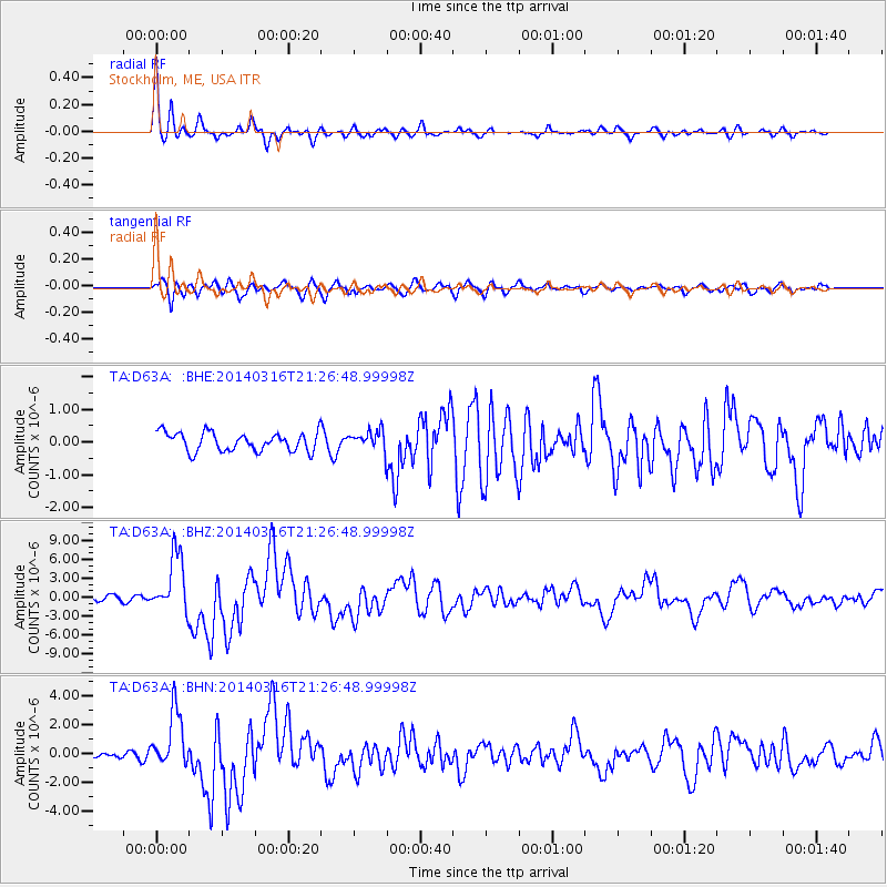
Signal To Noise
| Channel | StoN | STA | LTA |
| TA:D63A: :BHZ:20140316T21:26:48.99998Z | 9.825011 | 4.5970583E-6 | 4.6789341E-7 |
| TA:D63A: :BHN:20140316T21:26:48.99998Z | 8.021447 | 1.9779886E-6 | 2.465875E-7 |
| TA:D63A: :BHE:20140316T21:26:48.99998Z | 1.0527917 | 2.993685E-7 | 2.843568E-7 |
| Arrivals |
| Ps | 2.4 SECOND |
| PpPs | 6.8 SECOND |
| PsPs/PpSs | 9.2 SECOND |


