You are here: Home > Network List > TA - USArray Transportable Network (new EarthScope stations) Stations List
> Station E47A Iron Bridge, ON, CAN > Earthquake Result Viewer
E47A Iron Bridge, ON, CAN - Earthquake Result Viewer
| Earthquake location: |
Near Coast Of Northern Chile |
| Earthquake latitude/longitude: |
-19.9/-70.6 |
| Earthquake time(UTC): |
2014/03/16 (075) 21:16:30 GMT |
| Earthquake Depth: |
20 km |
| Earthquake Magnitude: |
6.7 MWW, 6.7 MWC, 7.0 MI |
| Earthquake Catalog/Contributor: |
NEIC PDE/NEIC COMCAT |
|
| Network: |
TA USArray Transportable Network (new EarthScope stations) |
| Station: |
E47A Iron Bridge, ON, CAN |
| Lat/Lon: |
46.45 N/83.28 W |
| Elevation: |
246 m |
|
| Distance: |
67.1 deg |
| Az: |
350.537 deg |
| Baz: |
167.07 deg |
| Ray Param: |
0.057188507 |
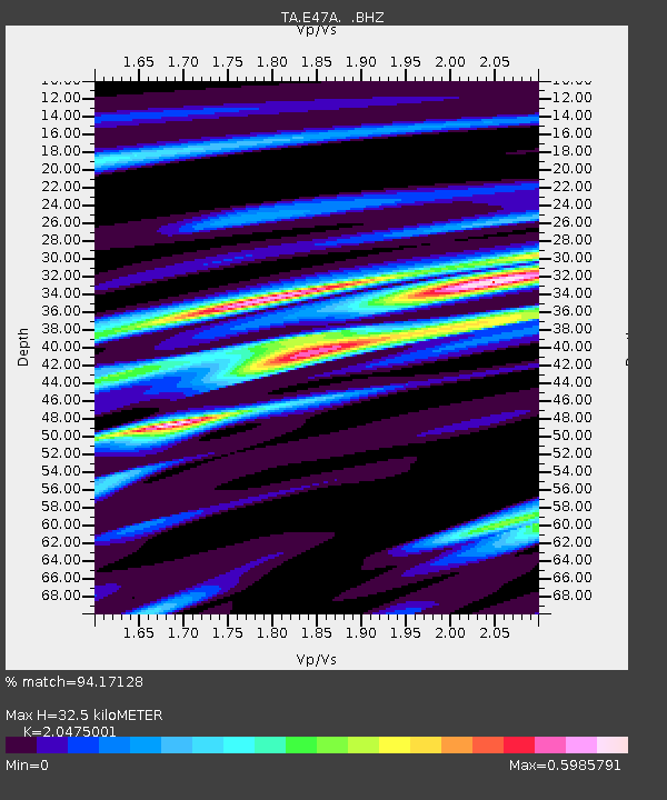
| Estimated Moho Depth: |
32.5 km |
| Estimated Crust Vp/Vs: |
2.05 |
| Assumed Crust Vp: |
6.467 km/s |
| Estimated Crust Vs: |
3.158 km/s |
| Estimated Crust Poisson's Ratio: |
0.34 |
|
| Radial Match: |
94.17128 % |
| Radial Bump: |
358 |
| Transverse Match: |
67.04022 % |
| Transverse Bump: |
400 |
| SOD ConfigId: |
626651 |
| Insert Time: |
2014-04-21 07:32:22.563 +0000 |
| GWidth: |
2.5 |
| Max Bumps: |
400 |
| Tol: |
0.001 |
|

Signal To Noise
| Channel | StoN | STA | LTA |
| TA:E47A: :BHZ:20140316T21:26:51.324993Z | 13.342793 | 3.7481846E-6 | 2.8091455E-7 |
| TA:E47A: :BHN:20140316T21:26:51.324993Z | 10.406968 | 1.8188808E-6 | 1.7477528E-7 |
| TA:E47A: :BHE:20140316T21:26:51.324993Z | 1.7998207 | 3.5053418E-7 | 1.9476062E-7 |
| Arrivals |
| Ps | 5.5 SECOND |
| PpPs | 15 SECOND |
| PsPs/PpSs | 20 SECOND |


