You are here: Home > Network List > TA - USArray Transportable Network (new EarthScope stations) Stations List
> Station E48A Lockeyer, ON, CAN > Earthquake Result Viewer
E48A Lockeyer, ON, CAN - Earthquake Result Viewer
| Earthquake location: |
Near Coast Of Northern Chile |
| Earthquake latitude/longitude: |
-19.9/-70.6 |
| Earthquake time(UTC): |
2014/03/16 (075) 21:16:30 GMT |
| Earthquake Depth: |
20 km |
| Earthquake Magnitude: |
6.7 MWW, 6.7 MWC, 7.0 MI |
| Earthquake Catalog/Contributor: |
NEIC PDE/NEIC COMCAT |
|
| Network: |
TA USArray Transportable Network (new EarthScope stations) |
| Station: |
E48A Lockeyer, ON, CAN |
| Lat/Lon: |
46.48 N/82.17 W |
| Elevation: |
347 m |
|
| Distance: |
66.9 deg |
| Az: |
351.359 deg |
| Baz: |
168.196 deg |
| Ray Param: |
0.057280537 |
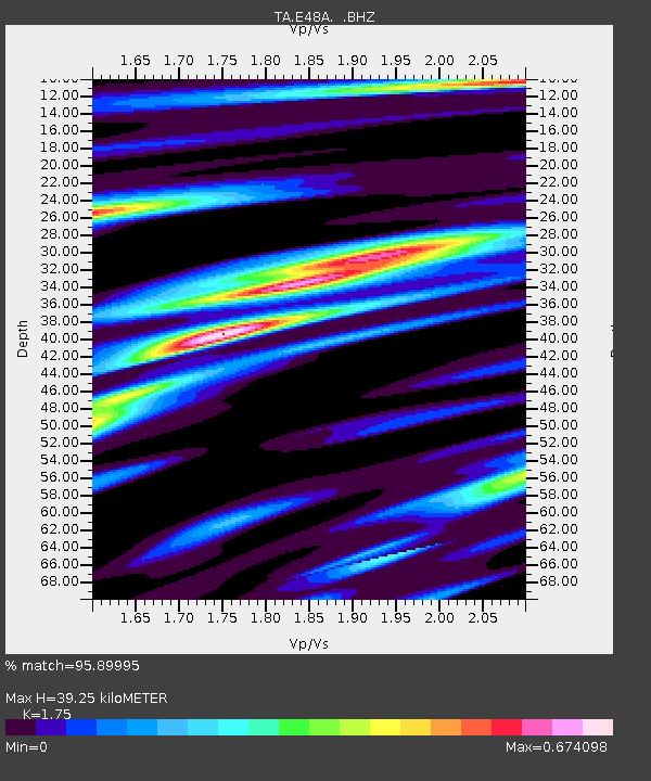
| Estimated Moho Depth: |
39.25 km |
| Estimated Crust Vp/Vs: |
1.75 |
| Assumed Crust Vp: |
6.467 km/s |
| Estimated Crust Vs: |
3.695 km/s |
| Estimated Crust Poisson's Ratio: |
0.26 |
|
| Radial Match: |
95.89995 % |
| Radial Bump: |
264 |
| Transverse Match: |
69.88967 % |
| Transverse Bump: |
400 |
| SOD ConfigId: |
626651 |
| Insert Time: |
2014-04-21 07:32:23.537 +0000 |
| GWidth: |
2.5 |
| Max Bumps: |
400 |
| Tol: |
0.001 |
|
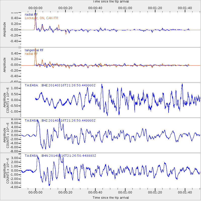
Signal To Noise
| Channel | StoN | STA | LTA |
| TA:E48A: :BHZ:20140316T21:26:50.449993Z | 19.289824 | 4.508151E-6 | 2.3370617E-7 |
| TA:E48A: :BHN:20140316T21:26:50.449993Z | 11.413062 | 1.9173592E-6 | 1.6799692E-7 |
| TA:E48A: :BHE:20140316T21:26:50.449993Z | 2.0011294 | 5.844834E-7 | 2.9207678E-7 |
| Arrivals |
| Ps | 4.7 SECOND |
| PpPs | 16 SECOND |
| PsPs/PpSs | 21 SECOND |


