You are here: Home > Network List > TA - USArray Transportable Network (new EarthScope stations) Stations List
> Station E54A Lac Daplat, Pontiac, MRC, QC, CAN > Earthquake Result Viewer
E54A Lac Daplat, Pontiac, MRC, QC, CAN - Earthquake Result Viewer
| Earthquake location: |
Near Coast Of Northern Chile |
| Earthquake latitude/longitude: |
-19.9/-70.6 |
| Earthquake time(UTC): |
2014/03/16 (075) 21:16:30 GMT |
| Earthquake Depth: |
20 km |
| Earthquake Magnitude: |
6.7 MWW, 6.7 MWC, 7.0 MI |
| Earthquake Catalog/Contributor: |
NEIC PDE/NEIC COMCAT |
|
| Network: |
TA USArray Transportable Network (new EarthScope stations) |
| Station: |
E54A Lac Daplat, Pontiac, MRC, QC, CAN |
| Lat/Lon: |
46.43 N/77.19 W |
| Elevation: |
277 m |
|
| Distance: |
66.3 deg |
| Az: |
355.051 deg |
| Baz: |
173.26 deg |
| Ray Param: |
0.05767909 |
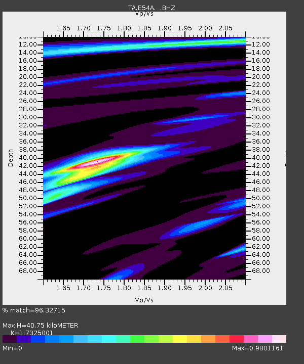
| Estimated Moho Depth: |
40.75 km |
| Estimated Crust Vp/Vs: |
1.73 |
| Assumed Crust Vp: |
6.622 km/s |
| Estimated Crust Vs: |
3.822 km/s |
| Estimated Crust Poisson's Ratio: |
0.25 |
|
| Radial Match: |
96.32715 % |
| Radial Bump: |
214 |
| Transverse Match: |
75.50608 % |
| Transverse Bump: |
400 |
| SOD ConfigId: |
626651 |
| Insert Time: |
2014-04-21 07:32:33.793 +0000 |
| GWidth: |
2.5 |
| Max Bumps: |
400 |
| Tol: |
0.001 |
|
Signal To Noise
| Channel | StoN | STA | LTA |
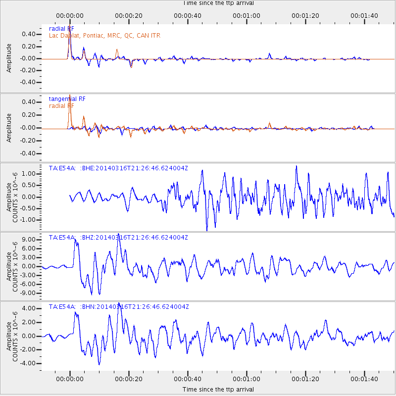
| TA:E54A: :BHZ:20140316T21:26:46.624004Z | 23.926754 | 4.856026E-6 | 2.0295381E-7 |
| TA:E54A: :BHN:20140316T21:26:46.624004Z | 9.039263 | 1.9230533E-6 | 2.127445E-7 |
| TA:E54A: :BHE:20140316T21:26:46.624004Z | 1.8012393 | 3.2515257E-7 | 1.8051604E-7 |
| Arrivals |
| Ps | 4.7 SECOND |
| PpPs | 16 SECOND |
| PsPs/PpSs | 21 SECOND |


