You are here: Home > Network List > TA - USArray Transportable Network (new EarthScope stations) Stations List
> Station E55A Montcerf-Lytton, QC, CAN > Earthquake Result Viewer
E55A Montcerf-Lytton, QC, CAN - Earthquake Result Viewer
| Earthquake location: |
Near Coast Of Northern Chile |
| Earthquake latitude/longitude: |
-19.9/-70.6 |
| Earthquake time(UTC): |
2014/03/16 (075) 21:16:30 GMT |
| Earthquake Depth: |
20 km |
| Earthquake Magnitude: |
6.7 MWW, 6.7 MWC, 7.0 MI |
| Earthquake Catalog/Contributor: |
NEIC PDE/NEIC COMCAT |
|
| Network: |
TA USArray Transportable Network (new EarthScope stations) |
| Station: |
E55A Montcerf-Lytton, QC, CAN |
| Lat/Lon: |
46.45 N/76.06 W |
| Elevation: |
180 m |
|
| Distance: |
66.2 deg |
| Az: |
355.902 deg |
| Baz: |
174.418 deg |
| Ray Param: |
0.05772097 |
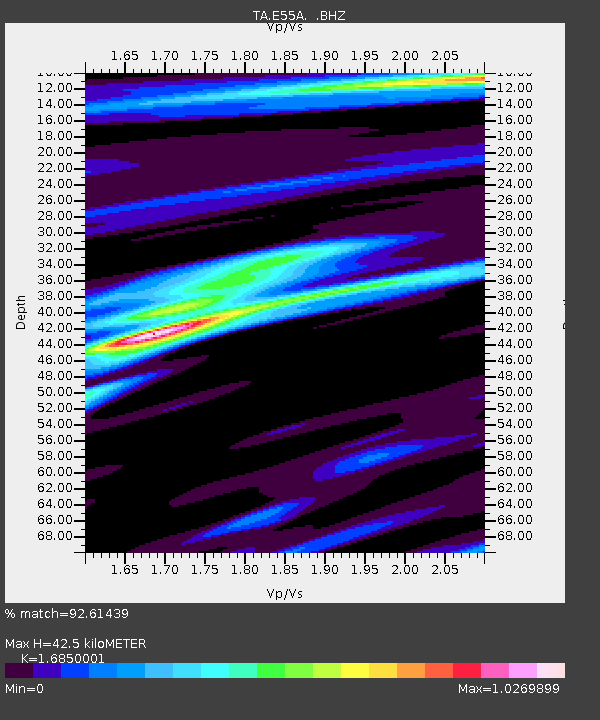
| Estimated Moho Depth: |
42.5 km |
| Estimated Crust Vp/Vs: |
1.69 |
| Assumed Crust Vp: |
6.622 km/s |
| Estimated Crust Vs: |
3.93 km/s |
| Estimated Crust Poisson's Ratio: |
0.23 |
|
| Radial Match: |
92.61439 % |
| Radial Bump: |
302 |
| Transverse Match: |
66.59097 % |
| Transverse Bump: |
400 |
| SOD ConfigId: |
626651 |
| Insert Time: |
2014-04-21 07:32:39.171 +0000 |
| GWidth: |
2.5 |
| Max Bumps: |
400 |
| Tol: |
0.001 |
|

Signal To Noise
| Channel | StoN | STA | LTA |
| TA:E55A: :BHZ:20140316T21:26:46.199993Z | 15.787128 | 4.7092267E-6 | 2.9829533E-7 |
| TA:E55A: :BHN:20140316T21:26:46.199993Z | 4.293445 | 1.6972613E-6 | 3.9531452E-7 |
| TA:E55A: :BHE:20140316T21:26:46.199993Z | 1.2195865 | 4.1068006E-7 | 3.3673712E-7 |
| Arrivals |
| Ps | 4.6 SECOND |
| PpPs | 16 SECOND |
| PsPs/PpSs | 21 SECOND |


