You are here: Home > Network List > TA - USArray Transportable Network (new EarthScope stations) Stations List
> Station F63A Nahmakanta, Browneville, ME, USA > Earthquake Result Viewer
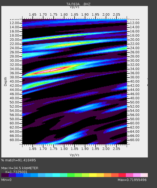
F63A Nahmakanta, Browneville, ME, USA - Earthquake Result Viewer
| Earthquake location: |
Near Coast Of Northern Chile |
| Earthquake latitude/longitude: |
-19.9/-70.6 |
| Earthquake time(UTC): |
2014/03/16 (075) 21:16:30 GMT |
| Earthquake Depth: |
20 km |
| Earthquake Magnitude: |
6.7 MWW, 6.7 MWC, 7.0 MI |
| Earthquake Catalog/Contributor: |
NEIC PDE/NEIC COMCAT |
|
| Network: |
TA USArray Transportable Network (new EarthScope stations) |
| Station: |
F63A Nahmakanta, Browneville, ME, USA |
| Lat/Lon: |
45.70 N/69.10 W |
| Elevation: |
386 m |
|
| Distance: |
65.3 deg |
| Az: |
1.176 deg |
| Baz: |
181.579 deg |
| Ray Param: |
0.05832346 |
| Estimated Moho Depth: |
34.5 km |
| Estimated Crust Vp/Vs: |
1.73 |
| Assumed Crust Vp: |
6.419 km/s |
| Estimated Crust Vs: |
3.705 km/s |
| Estimated Crust Poisson's Ratio: |
0.25 |
|
| Radial Match: |
91.418495 % |
| Radial Bump: |
400 |
| Transverse Match: |
71.39762 % |
| Transverse Bump: |
400 |
| SOD ConfigId: |
626651 |
| Insert Time: |
2014-04-21 07:33:34.677 +0000 |
| GWidth: |
2.5 |
| Max Bumps: |
400 |
| Tol: |
0.001 |
|

Signal To Noise
| Channel | StoN | STA | LTA |
| TA:F63A: :BHZ:20140316T21:26:40.300029Z | 6.432697 | 4.337377E-6 | 6.742704E-7 |
| TA:F63A: :BHN:20140316T21:26:40.300029Z | 4.3063197 | 2.083463E-6 | 4.838152E-7 |
| TA:F63A: :BHE:20140316T21:26:40.300029Z | 1.0003604 | 5.4511185E-7 | 5.449155E-7 |
| Arrivals |
| Ps | 4.1 SECOND |
| PpPs | 14 SECOND |
| PsPs/PpSs | 18 SECOND |


