You are here: Home > Network List > TA - USArray Transportable Network (new EarthScope stations) Stations List
> Station F64A Sherman, ME, USA > Earthquake Result Viewer
F64A Sherman, ME, USA - Earthquake Result Viewer
| Earthquake location: |
Near Coast Of Northern Chile |
| Earthquake latitude/longitude: |
-19.9/-70.6 |
| Earthquake time(UTC): |
2014/03/16 (075) 21:16:30 GMT |
| Earthquake Depth: |
20 km |
| Earthquake Magnitude: |
6.7 MWW, 6.7 MWC, 7.0 MI |
| Earthquake Catalog/Contributor: |
NEIC PDE/NEIC COMCAT |
|
| Network: |
TA USArray Transportable Network (new EarthScope stations) |
| Station: |
F64A Sherman, ME, USA |
| Lat/Lon: |
45.86 N/68.35 W |
| Elevation: |
179 m |
|
| Distance: |
65.5 deg |
| Az: |
1.749 deg |
| Baz: |
182.356 deg |
| Ray Param: |
0.058206394 |
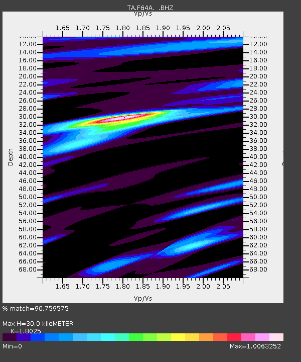
| Estimated Moho Depth: |
30.0 km |
| Estimated Crust Vp/Vs: |
1.80 |
| Assumed Crust Vp: |
6.419 km/s |
| Estimated Crust Vs: |
3.561 km/s |
| Estimated Crust Poisson's Ratio: |
0.28 |
|
| Radial Match: |
90.759575 % |
| Radial Bump: |
400 |
| Transverse Match: |
69.96468 % |
| Transverse Bump: |
400 |
| SOD ConfigId: |
626651 |
| Insert Time: |
2014-04-21 07:33:38.289 +0000 |
| GWidth: |
2.5 |
| Max Bumps: |
400 |
| Tol: |
0.001 |
|

Signal To Noise
| Channel | StoN | STA | LTA |
| TA:F64A: :BHZ:20140316T21:26:41.449993Z | 6.2309155 | 3.614011E-6 | 5.800128E-7 |
| TA:F64A: :BHN:20140316T21:26:41.449993Z | 4.5476637 | 1.7468469E-6 | 3.8411963E-7 |
| TA:F64A: :BHE:20140316T21:26:41.449993Z | 1.191472 | 4.4429297E-7 | 3.7289414E-7 |
| Arrivals |
| Ps | 3.9 SECOND |
| PpPs | 13 SECOND |
| PsPs/PpSs | 16 SECOND |


