You are here: Home > Network List > TA - USArray Transportable Network (new EarthScope stations) Stations List
> Station G57A Newington, ON, CAN > Earthquake Result Viewer
G57A Newington, ON, CAN - Earthquake Result Viewer
| Earthquake location: |
Near Coast Of Northern Chile |
| Earthquake latitude/longitude: |
-19.9/-70.6 |
| Earthquake time(UTC): |
2014/03/16 (075) 21:16:30 GMT |
| Earthquake Depth: |
20 km |
| Earthquake Magnitude: |
6.7 MWW, 6.7 MWC, 7.0 MI |
| Earthquake Catalog/Contributor: |
NEIC PDE/NEIC COMCAT |
|
| Network: |
TA USArray Transportable Network (new EarthScope stations) |
| Station: |
G57A Newington, ON, CAN |
| Lat/Lon: |
45.10 N/74.99 W |
| Elevation: |
96 m |
|
| Distance: |
64.8 deg |
| Az: |
356.592 deg |
| Baz: |
175.47 deg |
| Ray Param: |
0.058646563 |
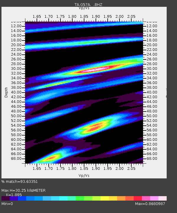
| Estimated Moho Depth: |
30.25 km |
| Estimated Crust Vp/Vs: |
1.89 |
| Assumed Crust Vp: |
6.419 km/s |
| Estimated Crust Vs: |
3.387 km/s |
| Estimated Crust Poisson's Ratio: |
0.31 |
|
| Radial Match: |
93.63351 % |
| Radial Bump: |
348 |
| Transverse Match: |
75.34828 % |
| Transverse Bump: |
400 |
| SOD ConfigId: |
626651 |
| Insert Time: |
2014-04-21 07:33:59.326 +0000 |
| GWidth: |
2.5 |
| Max Bumps: |
400 |
| Tol: |
0.001 |
|
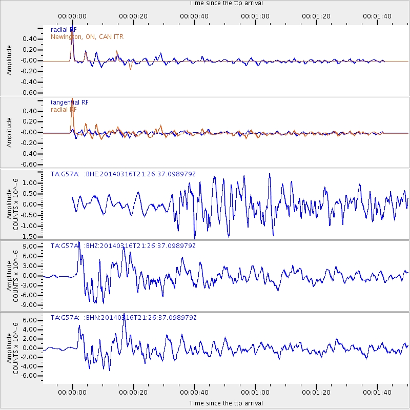
Signal To Noise
| Channel | StoN | STA | LTA |
| TA:G57A: :BHZ:20140316T21:26:37.098979Z | 14.962261 | 4.529424E-6 | 3.0272324E-7 |
| TA:G57A: :BHN:20140316T21:26:37.098979Z | 11.905437 | 2.120128E-6 | 1.7808065E-7 |
| TA:G57A: :BHE:20140316T21:26:37.098979Z | 1.6982161 | 4.5347116E-7 | 2.6702796E-7 |
| Arrivals |
| Ps | 4.4 SECOND |
| PpPs | 13 SECOND |
| PsPs/PpSs | 18 SECOND |


