You are here: Home > Network List > TJ - Tajikistan National Seismic Network Stations List
> Station GARM Garm, Tajikistan > Earthquake Result Viewer
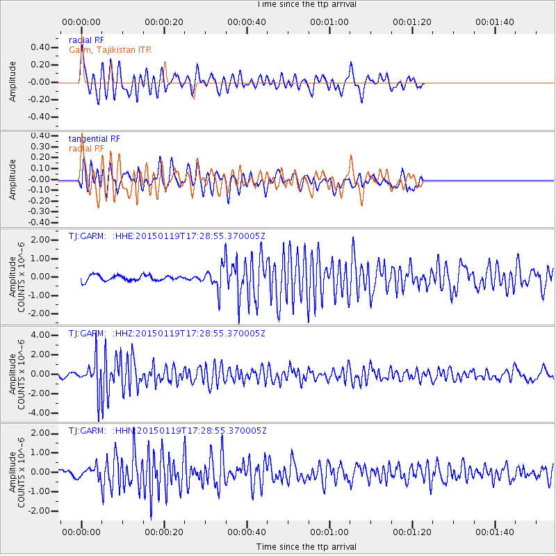
GARM Garm, Tajikistan - Earthquake Result Viewer
*The percent match for this event was below the threshold and hence no stack was calculated.
| Earthquake location: |
Sulu Archipelago, Philippines |
| Earthquake latitude/longitude: |
4.6/119.8 |
| Earthquake time(UTC): |
2015/01/19 (019) 17:19:45 GMT |
| Earthquake Depth: |
11 km |
| Earthquake Magnitude: |
5.5 MWB |
| Earthquake Catalog/Contributor: |
NEIC PDE/NEIC COMCAT |
|
| Network: |
TJ Tajikistan National Seismic Network |
| Station: |
GARM Garm, Tajikistan |
| Lat/Lon: |
39.00 N/70.32 E |
| Elevation: |
1305 m |
|
| Distance: |
56.3 deg |
| Az: |
314.618 deg |
| Baz: |
114.416 deg |
| Ray Param: |
$rayparam |
*The percent match for this event was below the threshold and hence was not used in the summary stack. |
|
| Radial Match: |
65.75235 % |
| Radial Bump: |
400 |
| Transverse Match: |
64.98776 % |
| Transverse Bump: |
400 |
| SOD ConfigId: |
3390531 |
| Insert Time: |
2019-04-16 03:07:32.050 +0000 |
| GWidth: |
2.5 |
| Max Bumps: |
400 |
| Tol: |
0.001 |
|
Signal To Noise
| Channel | StoN | STA | LTA |
| TJ:GARM: :HHZ:20150119T17:28:55.370005Z | 6.6227427 | 1.6373106E-6 | 2.4722547E-7 |
| TJ:GARM: :HHN:20150119T17:28:55.370005Z | 1.3678637 | 2.8817118E-7 | 2.1067245E-7 |
| TJ:GARM: :HHE:20150119T17:28:55.370005Z | 3.85148 | 5.714404E-7 | 1.4836905E-7 |
| Arrivals |
| Ps | |
| PpPs | |
| PsPs/PpSs | |


