You are here: Home > Network List > TA - USArray Transportable Network (new EarthScope stations) Stations List
> Station I48A Sherman Twp, MI, USA > Earthquake Result Viewer
I48A Sherman Twp, MI, USA - Earthquake Result Viewer
| Earthquake location: |
Near Coast Of Northern Chile |
| Earthquake latitude/longitude: |
-19.9/-70.6 |
| Earthquake time(UTC): |
2014/03/16 (075) 21:16:30 GMT |
| Earthquake Depth: |
20 km |
| Earthquake Magnitude: |
6.7 MWW, 6.7 MWC, 7.0 MI |
| Earthquake Catalog/Contributor: |
NEIC PDE/NEIC COMCAT |
|
| Network: |
TA USArray Transportable Network (new EarthScope stations) |
| Station: |
I48A Sherman Twp, MI, USA |
| Lat/Lon: |
44.19 N/83.70 W |
| Elevation: |
192 m |
|
| Distance: |
64.9 deg |
| Az: |
349.648 deg |
| Baz: |
166.408 deg |
| Ray Param: |
0.058596015 |
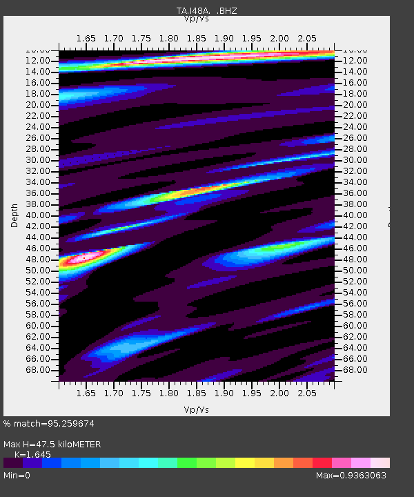
| Estimated Moho Depth: |
47.5 km |
| Estimated Crust Vp/Vs: |
1.64 |
| Assumed Crust Vp: |
6.483 km/s |
| Estimated Crust Vs: |
3.941 km/s |
| Estimated Crust Poisson's Ratio: |
0.21 |
|
| Radial Match: |
95.259674 % |
| Radial Bump: |
387 |
| Transverse Match: |
79.44932 % |
| Transverse Bump: |
400 |
| SOD ConfigId: |
626651 |
| Insert Time: |
2014-04-21 07:35:36.023 +0000 |
| GWidth: |
2.5 |
| Max Bumps: |
400 |
| Tol: |
0.001 |
|

Signal To Noise
| Channel | StoN | STA | LTA |
| TA:I48A: :BHZ:20140316T21:26:37.62498Z | 15.399014 | 5.535937E-6 | 3.5949944E-7 |
| TA:I48A: :BHN:20140316T21:26:37.62498Z | 8.322327 | 2.4178262E-6 | 2.9052285E-7 |
| TA:I48A: :BHE:20140316T21:26:37.62498Z | 2.4924378 | 7.610419E-7 | 3.0534036E-7 |
| Arrivals |
| Ps | 4.9 SECOND |
| PpPs | 19 SECOND |
| PsPs/PpSs | 23 SECOND |


