You are here: Home > Network List > TA - USArray Transportable Network (new EarthScope stations) Stations List
> Station I55A Frankford, ON, CAN > Earthquake Result Viewer
I55A Frankford, ON, CAN - Earthquake Result Viewer
| Earthquake location: |
Near Coast Of Northern Chile |
| Earthquake latitude/longitude: |
-19.9/-70.6 |
| Earthquake time(UTC): |
2014/03/16 (075) 21:16:30 GMT |
| Earthquake Depth: |
20 km |
| Earthquake Magnitude: |
6.7 MWW, 6.7 MWC, 7.0 MI |
| Earthquake Catalog/Contributor: |
NEIC PDE/NEIC COMCAT |
|
| Network: |
TA USArray Transportable Network (new EarthScope stations) |
| Station: |
I55A Frankford, ON, CAN |
| Lat/Lon: |
44.22 N/77.68 W |
| Elevation: |
132 m |
|
| Distance: |
64.2 deg |
| Az: |
354.369 deg |
| Baz: |
172.624 deg |
| Ray Param: |
0.059085704 |
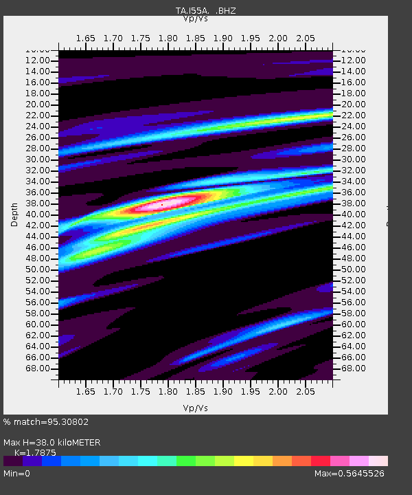
| Estimated Moho Depth: |
38.0 km |
| Estimated Crust Vp/Vs: |
1.79 |
| Assumed Crust Vp: |
6.577 km/s |
| Estimated Crust Vs: |
3.679 km/s |
| Estimated Crust Poisson's Ratio: |
0.27 |
|
| Radial Match: |
95.30802 % |
| Radial Bump: |
306 |
| Transverse Match: |
78.99396 % |
| Transverse Bump: |
400 |
| SOD ConfigId: |
626651 |
| Insert Time: |
2014-04-21 07:35:48.246 +0000 |
| GWidth: |
2.5 |
| Max Bumps: |
400 |
| Tol: |
0.001 |
|
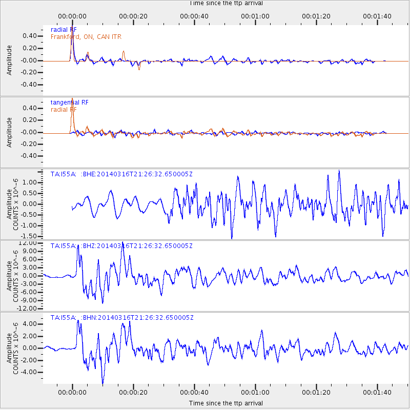
Signal To Noise
| Channel | StoN | STA | LTA |
| TA:I55A: :BHZ:20140316T21:26:32.650005Z | 9.505462 | 5.0454646E-6 | 5.307964E-7 |
| TA:I55A: :BHN:20140316T21:26:32.650005Z | 8.1300335 | 2.2980532E-6 | 2.8266223E-7 |
| TA:I55A: :BHE:20140316T21:26:32.650005Z | 1.6195539 | 4.8035577E-7 | 2.965976E-7 |
| Arrivals |
| Ps | 4.8 SECOND |
| PpPs | 15 SECOND |
| PsPs/PpSs | 20 SECOND |


