You are here: Home > Network List > TA - USArray Transportable Network (new EarthScope stations) Stations List
> Station J63A Strafford, NH, USA > Earthquake Result Viewer
J63A Strafford, NH, USA - Earthquake Result Viewer
| Earthquake location: |
Near Coast Of Northern Chile |
| Earthquake latitude/longitude: |
-19.9/-70.6 |
| Earthquake time(UTC): |
2014/03/16 (075) 21:16:30 GMT |
| Earthquake Depth: |
20 km |
| Earthquake Magnitude: |
6.7 MWW, 6.7 MWC, 7.0 MI |
| Earthquake Catalog/Contributor: |
NEIC PDE/NEIC COMCAT |
|
| Network: |
TA USArray Transportable Network (new EarthScope stations) |
| Station: |
J63A Strafford, NH, USA |
| Lat/Lon: |
43.28 N/71.08 W |
| Elevation: |
142 m |
|
| Distance: |
62.9 deg |
| Az: |
359.631 deg |
| Baz: |
179.524 deg |
| Ray Param: |
0.059910063 |
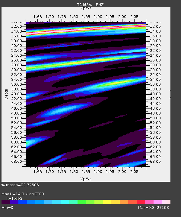
| Estimated Moho Depth: |
14.0 km |
| Estimated Crust Vp/Vs: |
1.70 |
| Assumed Crust Vp: |
6.419 km/s |
| Estimated Crust Vs: |
3.787 km/s |
| Estimated Crust Poisson's Ratio: |
0.23 |
|
| Radial Match: |
83.77586 % |
| Radial Bump: |
400 |
| Transverse Match: |
55.164562 % |
| Transverse Bump: |
400 |
| SOD ConfigId: |
626651 |
| Insert Time: |
2014-04-21 07:37:01.112 +0000 |
| GWidth: |
2.5 |
| Max Bumps: |
400 |
| Tol: |
0.001 |
|

Signal To Noise
| Channel | StoN | STA | LTA |
| TA:J63A: :BHZ:20140316T21:26:24.350017Z | 5.7803874 | 4.0041905E-6 | 6.9272005E-7 |
| TA:J63A: :BHN:20140316T21:26:24.350017Z | 5.067118 | 2.1662577E-6 | 4.2751276E-7 |
| TA:J63A: :BHE:20140316T21:26:24.350017Z | 1.0795631 | 5.8476957E-7 | 5.416724E-7 |
| Arrivals |
| Ps | 1.6 SECOND |
| PpPs | 5.6 SECOND |
| PsPs/PpSs | 7.2 SECOND |


