You are here: Home > Network List > TA - USArray Transportable Network (new EarthScope stations) Stations List
> Station K51A Iona Station, ON, CAN > Earthquake Result Viewer
K51A Iona Station, ON, CAN - Earthquake Result Viewer
| Earthquake location: |
Near Coast Of Northern Chile |
| Earthquake latitude/longitude: |
-19.9/-70.6 |
| Earthquake time(UTC): |
2014/03/16 (075) 21:16:30 GMT |
| Earthquake Depth: |
20 km |
| Earthquake Magnitude: |
6.7 MWW, 6.7 MWC, 7.0 MI |
| Earthquake Catalog/Contributor: |
NEIC PDE/NEIC COMCAT |
|
| Network: |
TA USArray Transportable Network (new EarthScope stations) |
| Station: |
K51A Iona Station, ON, CAN |
| Lat/Lon: |
42.72 N/81.51 W |
| Elevation: |
217 m |
|
| Distance: |
63.1 deg |
| Az: |
351.029 deg |
| Baz: |
168.517 deg |
| Ray Param: |
0.059751213 |
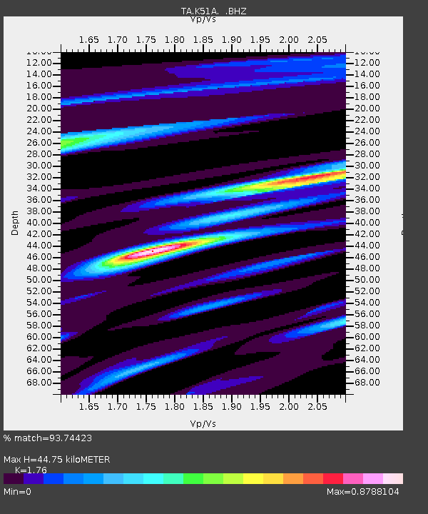
| Estimated Moho Depth: |
44.75 km |
| Estimated Crust Vp/Vs: |
1.76 |
| Assumed Crust Vp: |
6.53 km/s |
| Estimated Crust Vs: |
3.71 km/s |
| Estimated Crust Poisson's Ratio: |
0.26 |
|
| Radial Match: |
93.74423 % |
| Radial Bump: |
356 |
| Transverse Match: |
79.721954 % |
| Transverse Bump: |
400 |
| SOD ConfigId: |
626651 |
| Insert Time: |
2014-04-21 07:37:32.531 +0000 |
| GWidth: |
2.5 |
| Max Bumps: |
400 |
| Tol: |
0.001 |
|
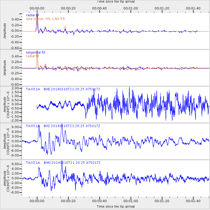
Signal To Noise
| Channel | StoN | STA | LTA |
| TA:K51A: :BHZ:20140316T21:26:25.975017Z | 14.776443 | 4.6608225E-6 | 3.154225E-7 |
| TA:K51A: :BHN:20140316T21:26:25.975017Z | 7.8901443 | 2.1019582E-6 | 2.6640302E-7 |
| TA:K51A: :BHE:20140316T21:26:25.975017Z | 2.0211267 | 5.6308966E-7 | 2.7860187E-7 |
| Arrivals |
| Ps | 5.5 SECOND |
| PpPs | 18 SECOND |
| PsPs/PpSs | 24 SECOND |


