You are here: Home > Network List > TA - USArray Transportable Network (new EarthScope stations) Stations List
> Station M47A Cromwell, IN, USA > Earthquake Result Viewer
M47A Cromwell, IN, USA - Earthquake Result Viewer
| Earthquake location: |
Near Coast Of Northern Chile |
| Earthquake latitude/longitude: |
-19.9/-70.6 |
| Earthquake time(UTC): |
2014/03/16 (075) 21:16:30 GMT |
| Earthquake Depth: |
20 km |
| Earthquake Magnitude: |
6.7 MWW, 6.7 MWC, 7.0 MI |
| Earthquake Catalog/Contributor: |
NEIC PDE/NEIC COMCAT |
|
| Network: |
TA USArray Transportable Network (new EarthScope stations) |
| Station: |
M47A Cromwell, IN, USA |
| Lat/Lon: |
41.36 N/85.62 W |
| Elevation: |
283 m |
|
| Distance: |
62.5 deg |
| Az: |
347.321 deg |
| Baz: |
164.078 deg |
| Ray Param: |
0.060137603 |
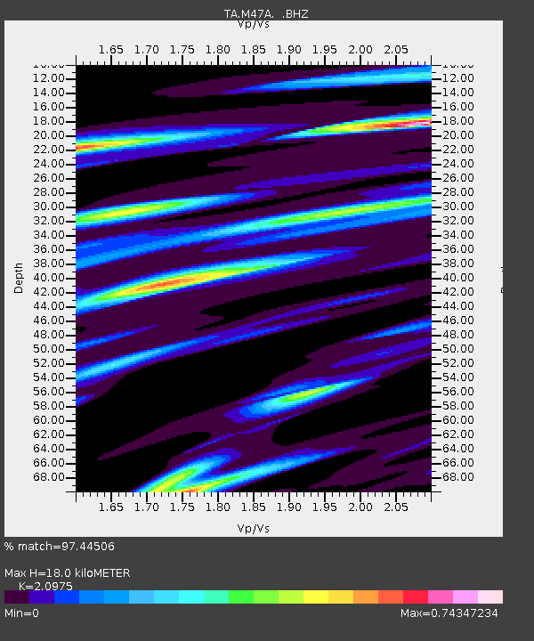
| Estimated Moho Depth: |
18.0 km |
| Estimated Crust Vp/Vs: |
2.10 |
| Assumed Crust Vp: |
6.498 km/s |
| Estimated Crust Vs: |
3.098 km/s |
| Estimated Crust Poisson's Ratio: |
0.35 |
|
| Radial Match: |
97.44506 % |
| Radial Bump: |
254 |
| Transverse Match: |
77.81055 % |
| Transverse Bump: |
400 |
| SOD ConfigId: |
626651 |
| Insert Time: |
2014-04-21 07:39:09.422 +0000 |
| GWidth: |
2.5 |
| Max Bumps: |
400 |
| Tol: |
0.001 |
|
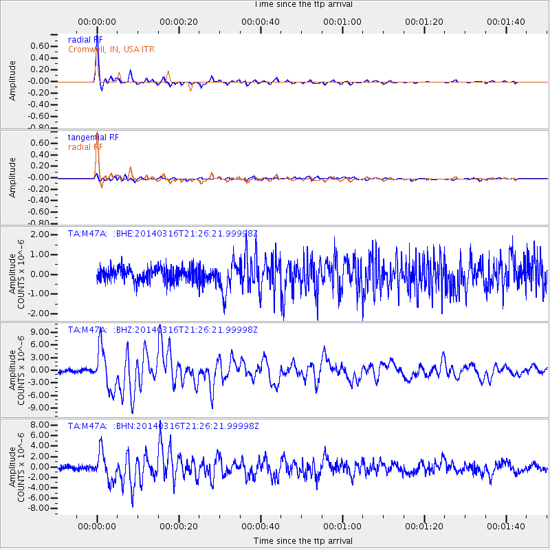
Signal To Noise
| Channel | StoN | STA | LTA |
| TA:M47A: :BHZ:20140316T21:26:21.99998Z | 15.807132 | 4.9036244E-6 | 3.1021594E-7 |
| TA:M47A: :BHN:20140316T21:26:21.99998Z | 7.597796 | 2.7376195E-6 | 3.6031759E-7 |
| TA:M47A: :BHE:20140316T21:26:21.99998Z | 2.217844 | 7.667384E-7 | 3.457134E-7 |
| Arrivals |
| Ps | 3.2 SECOND |
| PpPs | 8.3 SECOND |
| PsPs/PpSs | 11 SECOND |


