You are here: Home > Network List > TA - USArray Transportable Network (new EarthScope stations) Stations List
> Station M51A Elyria, OH, USA > Earthquake Result Viewer
M51A Elyria, OH, USA - Earthquake Result Viewer

| Earthquake location: |
Near Coast Of Northern Chile |
| Earthquake latitude/longitude: |
-19.9/-70.6 |
| Earthquake time(UTC): |
2014/03/16 (075) 21:16:30 GMT |
| Earthquake Depth: |
20 km |
| Earthquake Magnitude: |
6.7 MWW, 6.7 MWC, 7.0 MI |
| Earthquake Catalog/Contributor: |
NEIC PDE/NEIC COMCAT |
|
| Network: |
TA USArray Transportable Network (new EarthScope stations) |
| Station: |
M51A Elyria, OH, USA |
| Lat/Lon: |
41.33 N/82.18 W |
| Elevation: |
239 m |
|
| Distance: |
61.9 deg |
| Az: |
350.152 deg |
| Baz: |
167.661 deg |
| Ray Param: |
0.060571548 |
| Estimated Moho Depth: |
44.25 km |
| Estimated Crust Vp/Vs: |
1.77 |
| Assumed Crust Vp: |
6.498 km/s |
| Estimated Crust Vs: |
3.671 km/s |
| Estimated Crust Poisson's Ratio: |
0.27 |
|
| Radial Match: |
95.74574 % |
| Radial Bump: |
334 |
| Transverse Match: |
83.039696 % |
| Transverse Bump: |
400 |
| SOD ConfigId: |
626651 |
| Insert Time: |
2014-04-21 07:39:19.090 +0000 |
| GWidth: |
2.5 |
| Max Bumps: |
400 |
| Tol: |
0.001 |
|
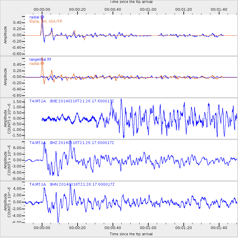
Signal To Noise
| Channel | StoN | STA | LTA |
| TA:M51A: :BHZ:20140316T21:26:17.600017Z | 15.701103 | 4.3814493E-6 | 2.7905358E-7 |
| TA:M51A: :BHN:20140316T21:26:17.600017Z | 7.777816 | 2.1201026E-6 | 2.7258332E-7 |
| TA:M51A: :BHE:20140316T21:26:17.600017Z | 1.6998106 | 3.233475E-7 | 1.902256E-7 |
| Arrivals |
| Ps | 5.5 SECOND |
| PpPs | 18 SECOND |
| PsPs/PpSs | 24 SECOND |


