You are here: Home > Network List > TA - USArray Transportable Network (new EarthScope stations) Stations List
> Station M52A Chesterland, OH, USA > Earthquake Result Viewer
M52A Chesterland, OH, USA - Earthquake Result Viewer
| Earthquake location: |
Near Coast Of Northern Chile |
| Earthquake latitude/longitude: |
-19.9/-70.6 |
| Earthquake time(UTC): |
2014/03/16 (075) 21:16:30 GMT |
| Earthquake Depth: |
20 km |
| Earthquake Magnitude: |
6.7 MWW, 6.7 MWC, 7.0 MI |
| Earthquake Catalog/Contributor: |
NEIC PDE/NEIC COMCAT |
|
| Network: |
TA USArray Transportable Network (new EarthScope stations) |
| Station: |
M52A Chesterland, OH, USA |
| Lat/Lon: |
41.54 N/81.36 W |
| Elevation: |
382 m |
|
| Distance: |
62.0 deg |
| Az: |
350.889 deg |
| Baz: |
168.553 deg |
| Ray Param: |
0.060523115 |
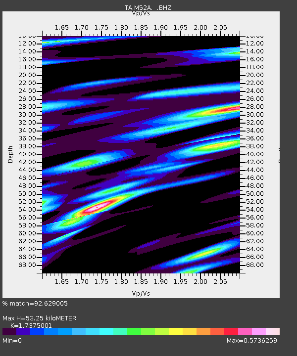
| Estimated Moho Depth: |
53.25 km |
| Estimated Crust Vp/Vs: |
1.74 |
| Assumed Crust Vp: |
6.483 km/s |
| Estimated Crust Vs: |
3.731 km/s |
| Estimated Crust Poisson's Ratio: |
0.25 |
|
| Radial Match: |
92.629005 % |
| Radial Bump: |
400 |
| Transverse Match: |
66.308975 % |
| Transverse Bump: |
400 |
| SOD ConfigId: |
626651 |
| Insert Time: |
2014-04-21 07:39:24.723 +0000 |
| GWidth: |
2.5 |
| Max Bumps: |
400 |
| Tol: |
0.001 |
|

Signal To Noise
| Channel | StoN | STA | LTA |
| TA:M52A: :BHZ:20140316T21:26:18.100017Z | 16.048767 | 4.3969644E-6 | 2.739752E-7 |
| TA:M52A: :BHN:20140316T21:26:18.100017Z | 10.7508 | 2.5575528E-6 | 2.3789418E-7 |
| TA:M52A: :BHE:20140316T21:26:18.100017Z | 2.0821805 | 4.5887163E-7 | 2.2038033E-7 |
| Arrivals |
| Ps | 6.3 SECOND |
| PpPs | 21 SECOND |
| PsPs/PpSs | 28 SECOND |


