You are here: Home > Network List > TA - USArray Transportable Network (new EarthScope stations) Stations List
> Station M57A Sunshine Farm, Cogan Station, PA, USA > Earthquake Result Viewer
M57A Sunshine Farm, Cogan Station, PA, USA - Earthquake Result Viewer
| Earthquake location: |
Near Coast Of Northern Chile |
| Earthquake latitude/longitude: |
-19.9/-70.6 |
| Earthquake time(UTC): |
2014/03/16 (075) 21:16:30 GMT |
| Earthquake Depth: |
20 km |
| Earthquake Magnitude: |
6.7 MWW, 6.7 MWC, 7.0 MI |
| Earthquake Catalog/Contributor: |
NEIC PDE/NEIC COMCAT |
|
| Network: |
TA USArray Transportable Network (new EarthScope stations) |
| Station: |
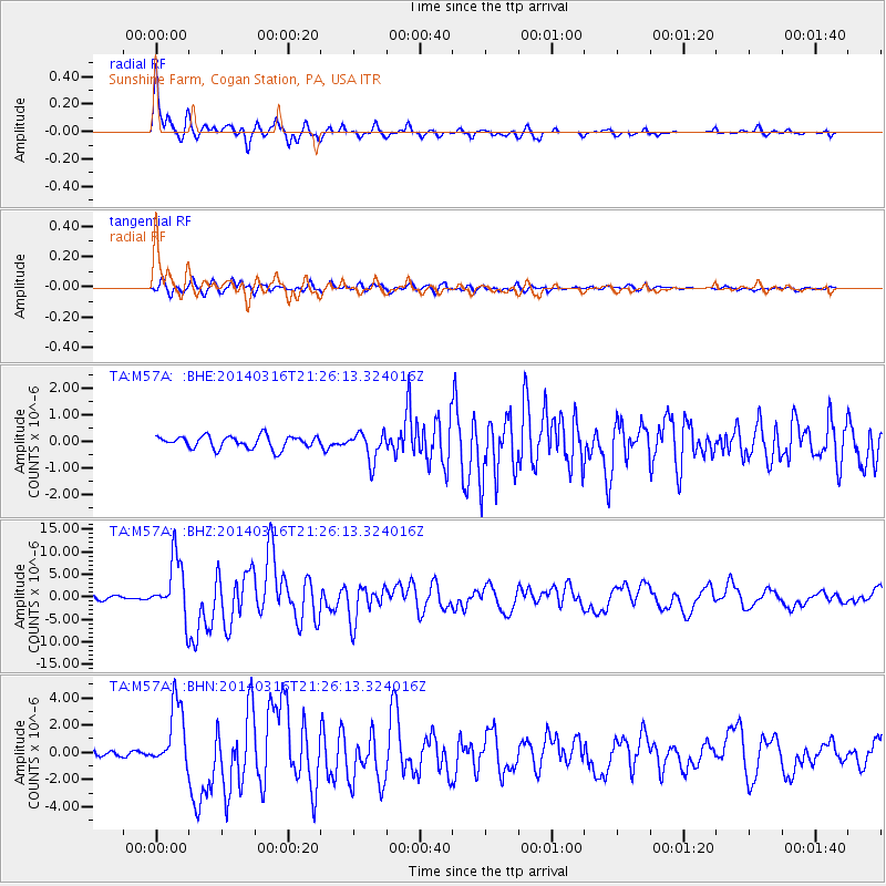
M57A Sunshine Farm, Cogan Station, PA, USA |
| Lat/Lon: |
41.34 N/77.13 W |
| Elevation: |
319 m |
|
| Distance: |
61.2 deg |
| Az: |
354.42 deg |
| Baz: |
173.022 deg |
| Ray Param: |
0.060975496 |
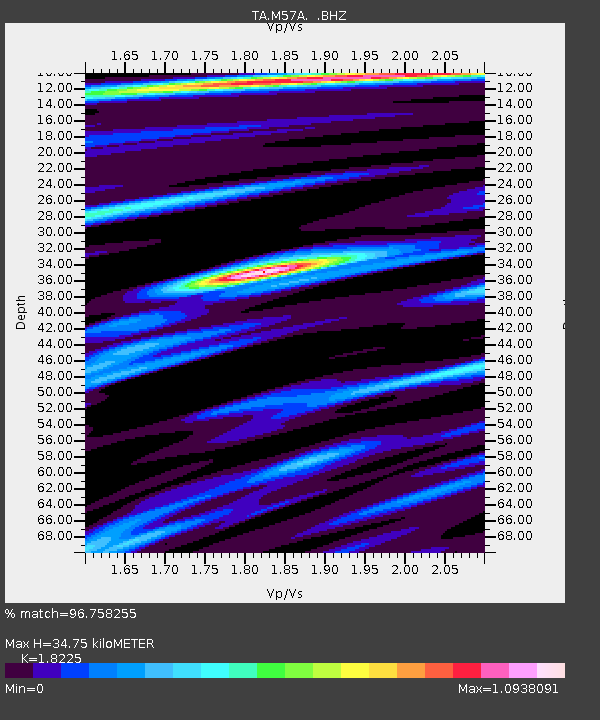
| Estimated Moho Depth: |
34.75 km |
| Estimated Crust Vp/Vs: |
1.82 |
| Assumed Crust Vp: |
6.121 km/s |
| Estimated Crust Vs: |
3.358 km/s |
| Estimated Crust Poisson's Ratio: |
0.28 |
|
| Radial Match: |
96.758255 % |
| Radial Bump: |
327 |
| Transverse Match: |
87.36025 % |
| Transverse Bump: |
400 |
| SOD ConfigId: |
626651 |
| Insert Time: |
2014-04-21 07:39:36.390 +0000 |
| GWidth: |
2.5 |
| Max Bumps: |
400 |
| Tol: |
0.001 |
|
Signal To Noise
| Channel | StoN | STA | LTA |
| TA:M57A: :BHZ:20140316T21:26:13.324016Z | 12.200223 | 6.4509013E-6 | 5.2875276E-7 |
| TA:M57A: :BHN:20140316T21:26:13.324016Z | 11.540638 | 2.3822195E-6 | 2.0642008E-7 |
| TA:M57A: :BHE:20140316T21:26:13.324016Z | 2.3329976 | 5.407727E-7 | 2.317931E-7 |
| Arrivals |
| Ps | 4.9 SECOND |
| PpPs | 15 SECOND |
| PsPs/PpSs | 20 SECOND |


