You are here: Home > Network List > TA - USArray Transportable Network (new EarthScope stations) Stations List
> Station M61A Granite Springs, NY, USA > Earthquake Result Viewer
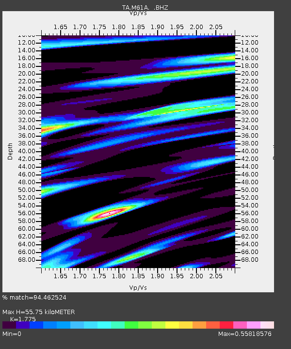
M61A Granite Springs, NY, USA - Earthquake Result Viewer
| Earthquake location: |
Near Coast Of Northern Chile |
| Earthquake latitude/longitude: |
-19.9/-70.6 |
| Earthquake time(UTC): |
2014/03/16 (075) 21:16:30 GMT |
| Earthquake Depth: |
20 km |
| Earthquake Magnitude: |
6.7 MWW, 6.7 MWC, 7.0 MI |
| Earthquake Catalog/Contributor: |
NEIC PDE/NEIC COMCAT |
|
| Network: |
TA USArray Transportable Network (new EarthScope stations) |
| Station: |
M61A Granite Springs, NY, USA |
| Lat/Lon: |
41.31 N/73.77 W |
| Elevation: |
190 m |
|
| Distance: |
61.0 deg |
| Az: |
357.296 deg |
| Baz: |
176.622 deg |
| Ray Param: |
0.06114414 |
| Estimated Moho Depth: |
55.75 km |
| Estimated Crust Vp/Vs: |
1.77 |
| Assumed Crust Vp: |
6.472 km/s |
| Estimated Crust Vs: |
3.646 km/s |
| Estimated Crust Poisson's Ratio: |
0.27 |
|
| Radial Match: |
94.462524 % |
| Radial Bump: |
326 |
| Transverse Match: |
81.791115 % |
| Transverse Bump: |
400 |
| SOD ConfigId: |
626651 |
| Insert Time: |
2014-04-21 07:39:46.536 +0000 |
| GWidth: |
2.5 |
| Max Bumps: |
400 |
| Tol: |
0.001 |
|

Signal To Noise
| Channel | StoN | STA | LTA |
| TA:M61A: :BHZ:20140316T21:26:11.598979Z | 10.307353 | 3.746459E-6 | 3.6347438E-7 |
| TA:M61A: :BHN:20140316T21:26:11.598979Z | 8.829309 | 1.8765389E-6 | 2.1253518E-7 |
| TA:M61A: :BHE:20140316T21:26:11.598979Z | 1.2400906 | 3.19431E-7 | 2.5758683E-7 |
| Arrivals |
| Ps | 7.0 SECOND |
| PpPs | 23 SECOND |
| PsPs/PpSs | 30 SECOND |


