You are here: Home > Network List > TA - USArray Transportable Network (new EarthScope stations) Stations List
> Station M62A Hamden, CT, USA > Earthquake Result Viewer
M62A Hamden, CT, USA - Earthquake Result Viewer
| Earthquake location: |
Near Coast Of Northern Chile |
| Earthquake latitude/longitude: |
-19.9/-70.6 |
| Earthquake time(UTC): |
2014/03/16 (075) 21:16:30 GMT |
| Earthquake Depth: |
20 km |
| Earthquake Magnitude: |
6.7 MWW, 6.7 MWC, 7.0 MI |
| Earthquake Catalog/Contributor: |
NEIC PDE/NEIC COMCAT |
|
| Network: |
TA USArray Transportable Network (new EarthScope stations) |
| Station: |
M62A Hamden, CT, USA |
| Lat/Lon: |
41.44 N/72.89 W |
| Elevation: |
24 m |
|
| Distance: |
61.1 deg |
| Az: |
358.054 deg |
| Baz: |
177.564 deg |
| Ray Param: |
0.061079178 |
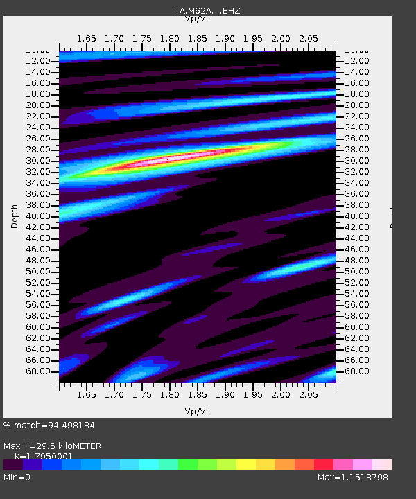
| Estimated Moho Depth: |
29.5 km |
| Estimated Crust Vp/Vs: |
1.80 |
| Assumed Crust Vp: |
6.472 km/s |
| Estimated Crust Vs: |
3.606 km/s |
| Estimated Crust Poisson's Ratio: |
0.27 |
|
| Radial Match: |
94.498184 % |
| Radial Bump: |
400 |
| Transverse Match: |
76.12612 % |
| Transverse Bump: |
400 |
| SOD ConfigId: |
626651 |
| Insert Time: |
2014-04-21 07:39:51.977 +0000 |
| GWidth: |
2.5 |
| Max Bumps: |
400 |
| Tol: |
0.001 |
|

Signal To Noise
| Channel | StoN | STA | LTA |
| TA:M62A: :BHZ:20140316T21:26:12.275005Z | 12.963957 | 5.330405E-6 | 4.1117116E-7 |
| TA:M62A: :BHN:20140316T21:26:12.275005Z | 7.0833263 | 2.6721173E-6 | 3.7724044E-7 |
| TA:M62A: :BHE:20140316T21:26:12.275005Z | 2.3260942 | 9.208133E-7 | 3.9586246E-7 |
| Arrivals |
| Ps | 3.8 SECOND |
| PpPs | 12 SECOND |
| PsPs/PpSs | 16 SECOND |


