You are here: Home > Network List > TA - USArray Transportable Network (new EarthScope stations) Stations List
> Station O03E Paynes Creek, CA, USA > Earthquake Result Viewer
O03E Paynes Creek, CA, USA - Earthquake Result Viewer
| Earthquake location: |
Near Coast Of Northern Chile |
| Earthquake latitude/longitude: |
-19.9/-70.6 |
| Earthquake time(UTC): |
2014/03/16 (075) 21:16:30 GMT |
| Earthquake Depth: |
20 km |
| Earthquake Magnitude: |
6.7 MWW, 6.7 MWC, 7.0 MI |
| Earthquake Catalog/Contributor: |
NEIC PDE/NEIC COMCAT |
|
| Network: |
TA USArray Transportable Network (new EarthScope stations) |
| Station: |
O03E Paynes Creek, CA, USA |
| Lat/Lon: |
40.29 N/121.80 W |
| Elevation: |
967 m |
|
| Distance: |
76.5 deg |
| Az: |
322.213 deg |
| Baz: |
131.086 deg |
| Ray Param: |
0.05091435 |
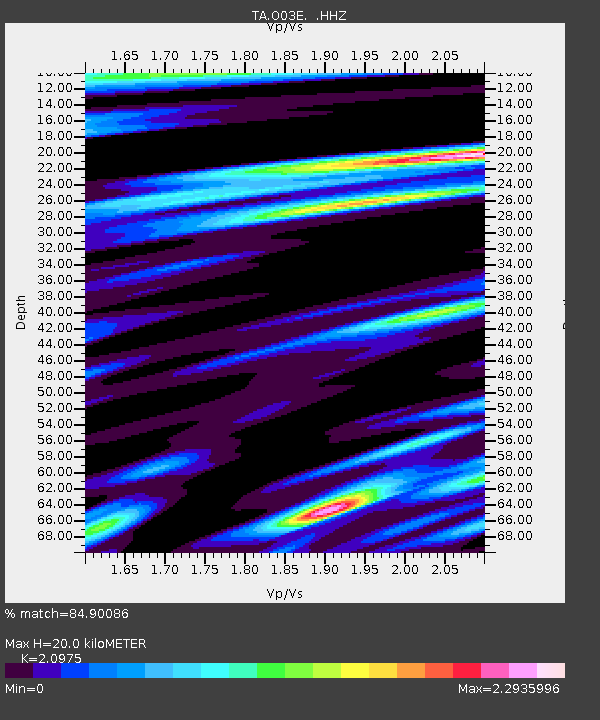
| Estimated Moho Depth: |
20.0 km |
| Estimated Crust Vp/Vs: |
2.10 |
| Assumed Crust Vp: |
6.566 km/s |
| Estimated Crust Vs: |
3.13 km/s |
| Estimated Crust Poisson's Ratio: |
0.35 |
|
| Radial Match: |
84.90086 % |
| Radial Bump: |
400 |
| Transverse Match: |
68.42896 % |
| Transverse Bump: |
400 |
| SOD ConfigId: |
626651 |
| Insert Time: |
2014-04-21 07:41:02.606 +0000 |
| GWidth: |
2.5 |
| Max Bumps: |
400 |
| Tol: |
0.001 |
|
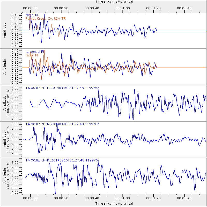
Signal To Noise
| Channel | StoN | STA | LTA |
| TA:O03E: :HHZ:20140316T21:27:48.119976Z | 2.7675004 | 2.0465816E-6 | 7.395054E-7 |
| TA:O03E: :HHN:20140316T21:27:48.119976Z | 1.7520816 | 5.3575906E-7 | 3.0578428E-7 |
| TA:O03E: :HHE:20140316T21:27:48.119976Z | 1.1759617 | 7.5651604E-7 | 6.4331687E-7 |
| Arrivals |
| Ps | 3.4 SECOND |
| PpPs | 9.2 SECOND |
| PsPs/PpSs | 13 SECOND |


