You are here: Home > Network List > TA - USArray Transportable Network (new EarthScope stations) Stations List
> Station O56A Blue Knob State Park, Imler, PA, USA > Earthquake Result Viewer
O56A Blue Knob State Park, Imler, PA, USA - Earthquake Result Viewer

| Earthquake location: |
Near Coast Of Northern Chile |
| Earthquake latitude/longitude: |
-19.9/-70.6 |
| Earthquake time(UTC): |
2014/03/16 (075) 21:16:30 GMT |
| Earthquake Depth: |
20 km |
| Earthquake Magnitude: |
6.7 MWW, 6.7 MWC, 7.0 MI |
| Earthquake Catalog/Contributor: |
NEIC PDE/NEIC COMCAT |
|
| Network: |
TA USArray Transportable Network (new EarthScope stations) |
| Station: |
O56A Blue Knob State Park, Imler, PA, USA |
| Lat/Lon: |
40.27 N/78.57 W |
| Elevation: |
684 m |
|
| Distance: |
60.3 deg |
| Az: |
353.015 deg |
| Baz: |
171.4 deg |
| Ray Param: |
0.06157695 |
| Estimated Moho Depth: |
14.75 km |
| Estimated Crust Vp/Vs: |
1.60 |
| Assumed Crust Vp: |
6.121 km/s |
| Estimated Crust Vs: |
3.825 km/s |
| Estimated Crust Poisson's Ratio: |
0.18 |
|
| Radial Match: |
95.7913 % |
| Radial Bump: |
394 |
| Transverse Match: |
85.54485 % |
| Transverse Bump: |
400 |
| SOD ConfigId: |
626651 |
| Insert Time: |
2014-04-21 07:41:28.374 +0000 |
| GWidth: |
2.5 |
| Max Bumps: |
400 |
| Tol: |
0.001 |
|
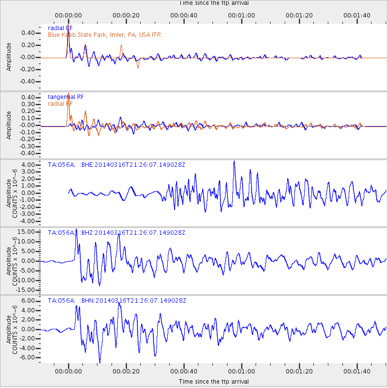
Signal To Noise
| Channel | StoN | STA | LTA |
| TA:O56A: :BHZ:20140316T21:26:07.149028Z | 19.078566 | 6.5030804E-6 | 3.4085792E-7 |
| TA:O56A: :BHN:20140316T21:26:07.149028Z | 9.212688 | 2.2905613E-6 | 2.4863115E-7 |
| TA:O56A: :BHE:20140316T21:26:07.149028Z | 1.4868233 | 5.2227773E-7 | 3.5127087E-7 |
| Arrivals |
| Ps | 1.5 SECOND |
| PpPs | 6.0 SECOND |
| PsPs/PpSs | 7.5 SECOND |


