You are here: Home > Network List > TA - USArray Transportable Network (new EarthScope stations) Stations List
> Station P48A Milroy, IN, USA > Earthquake Result Viewer
P48A Milroy, IN, USA - Earthquake Result Viewer
| Earthquake location: |
Near Coast Of Northern Chile |
| Earthquake latitude/longitude: |
-19.9/-70.6 |
| Earthquake time(UTC): |
2014/03/16 (075) 21:16:30 GMT |
| Earthquake Depth: |
20 km |
| Earthquake Magnitude: |
6.7 MWW, 6.7 MWC, 7.0 MI |
| Earthquake Catalog/Contributor: |
NEIC PDE/NEIC COMCAT |
|
| Network: |
TA USArray Transportable Network (new EarthScope stations) |
| Station: |
P48A Milroy, IN, USA |
| Lat/Lon: |
39.46 N/85.43 W |
| Elevation: |
300 m |
|
| Distance: |
60.7 deg |
| Az: |
346.892 deg |
| Baz: |
164.0 deg |
| Ray Param: |
0.061353777 |
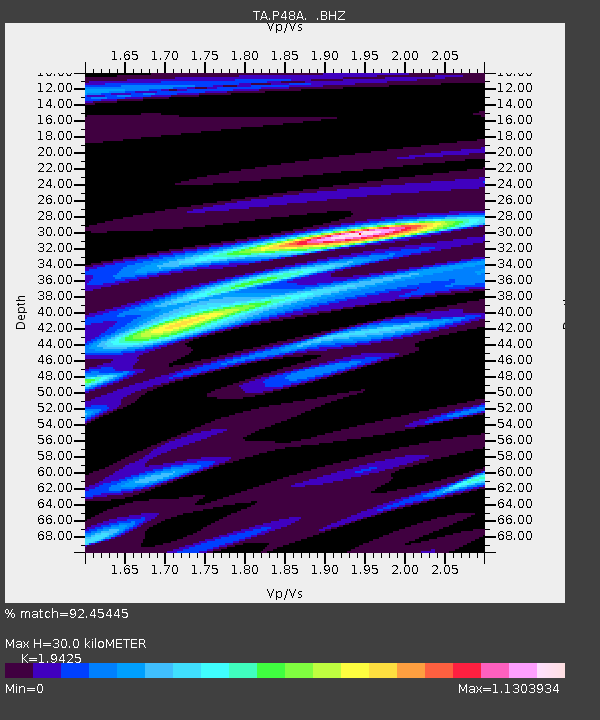
| Estimated Moho Depth: |
30.0 km |
| Estimated Crust Vp/Vs: |
1.94 |
| Assumed Crust Vp: |
6.498 km/s |
| Estimated Crust Vs: |
3.345 km/s |
| Estimated Crust Poisson's Ratio: |
0.32 |
|
| Radial Match: |
92.45445 % |
| Radial Bump: |
356 |
| Transverse Match: |
78.830826 % |
| Transverse Bump: |
400 |
| SOD ConfigId: |
626651 |
| Insert Time: |
2014-04-21 07:41:42.370 +0000 |
| GWidth: |
2.5 |
| Max Bumps: |
400 |
| Tol: |
0.001 |
|

Signal To Noise
| Channel | StoN | STA | LTA |
| TA:P48A: :BHZ:20140316T21:26:09.449993Z | 18.83224 | 4.3156456E-6 | 2.2916264E-7 |
| TA:P48A: :BHN:20140316T21:26:09.449993Z | 8.720026 | 2.1825888E-6 | 2.5029615E-7 |
| TA:P48A: :BHE:20140316T21:26:09.449993Z | 3.816732 | 6.3921743E-7 | 1.6747768E-7 |
| Arrivals |
| Ps | 4.5 SECOND |
| PpPs | 13 SECOND |
| PsPs/PpSs | 18 SECOND |


