You are here: Home > Network List > TA - USArray Transportable Network (new EarthScope stations) Stations List
> Station P56A Dayton Farm, Ripley, WV, USA > Earthquake Result Viewer
P56A Dayton Farm, Ripley, WV, USA - Earthquake Result Viewer
| Earthquake location: |
Near Coast Of Northern Chile |
| Earthquake latitude/longitude: |
-19.9/-70.6 |
| Earthquake time(UTC): |
2014/03/16 (075) 21:16:30 GMT |
| Earthquake Depth: |
20 km |
| Earthquake Magnitude: |
6.7 MWW, 6.7 MWC, 7.0 MI |
| Earthquake Catalog/Contributor: |
NEIC PDE/NEIC COMCAT |
|
| Network: |
TA USArray Transportable Network (new EarthScope stations) |
| Station: |
P56A Dayton Farm, Ripley, WV, USA |
| Lat/Lon: |
39.50 N/78.84 W |
| Elevation: |
249 m |
|
| Distance: |
59.6 deg |
| Az: |
352.641 deg |
| Baz: |
171.039 deg |
| Ray Param: |
0.06204915 |
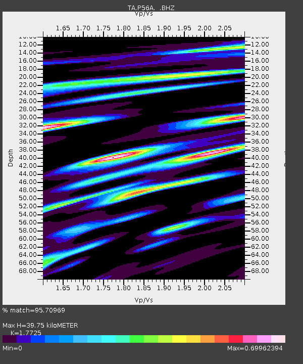
| Estimated Moho Depth: |
39.75 km |
| Estimated Crust Vp/Vs: |
1.77 |
| Assumed Crust Vp: |
6.159 km/s |
| Estimated Crust Vs: |
3.475 km/s |
| Estimated Crust Poisson's Ratio: |
0.27 |
|
| Radial Match: |
95.70969 % |
| Radial Bump: |
400 |
| Transverse Match: |
86.35411 % |
| Transverse Bump: |
400 |
| SOD ConfigId: |
626651 |
| Insert Time: |
2014-04-21 07:42:04.103 +0000 |
| GWidth: |
2.5 |
| Max Bumps: |
400 |
| Tol: |
0.001 |
|

Signal To Noise
| Channel | StoN | STA | LTA |
| TA:P56A: :BHZ:20140316T21:26:02.199993Z | 19.830875 | 5.79597E-6 | 2.9227002E-7 |
| TA:P56A: :BHN:20140316T21:26:02.199993Z | 17.295599 | 2.8446439E-6 | 1.6447211E-7 |
| TA:P56A: :BHE:20140316T21:26:02.199993Z | 2.4381313 | 5.299443E-7 | 2.1735676E-7 |
| Arrivals |
| Ps | 5.2 SECOND |
| PpPs | 17 SECOND |
| PsPs/PpSs | 22 SECOND |


